Purdue GIS Day 2024: Exploring GeoAI
Thursday, November 7, 2024 in Stewart Center
Purdue GIS Day 2024, with the theme of “Exploring GeoAI,” was a success and brought together over 180 students, academics, and industry professionals in a day filled with insightful talks, poster presentations, and networking opportunities. The event, hosted by Gang Shao, showcased the latest advancements in geospatial analysis and its applications across many disciplines.
Agenda
View the agenda of the 2024 conference.
Keynote Speakers

Gregory Brunner
Presentation: The Burgeoning AI Model Ecosystem and Its Impact on GIS
Brunner is an experienced scientist, award-winning professor, and principal data scientist at Esri, the global market leader in GIS software, location intelligence, and mapping. He spoke about the rapid growth of the AI model ecosystem and the potential impact it has and will have on GIS in his talk titled, “The Burgeoning AI Model Ecosystem and Its Potential Impact on GIS.”
Through his vision and guidance, he has helped organizations across the world understand how to manage, disseminate, and analyze vast quantities of imagery in support of a wide range of missions and problems. Brunner’s current focus is on developing custom AI and computer vision-driven spatial analysis tools in support of extracting features from imagery and attributing those features. He also explores extended reality applications and the incorporation of 3D GIS data into extended-reality environments.
As a dedicated and enthusiastic teacher, Brunner served as an adjunct professor at Saint Louis University from 2017 through 2022, where he was the recipient of the 2019 award for Excellence in Adjunct Teaching. Brunner has written multiple lesson paths for Esri’s ArcGIS Learn website that teaches ArcGIS users how to use the ArcGIS API for Python for data science. Brunner’s unique ability to solve abstract quantitative geographic problems and explain those solutions has enabled him to give presentations around the world on topics such as advanced image processing, augmented reality, and GeoAI.

Michael Johns
Presentation: Any-Scale Spatial Analysis on Databricks
Johns joined Databricks in 2017 as the first solutions architect for Public Sector, before taking on a field engineering manager role for a few years, and then turned his full attention to Geospatial in 2022. Prior to Databricks, he performed engineering functions in an identity management product and a commercial semantic network analysis product, and researched the application of graph analysis techniques over motion imagery processing systems. He discussed how to use Databricks to perform scaled spatial analysis while retaining full visibility and control over all of the underlying processes, code, models, and data lineage in his talk titled, “Any-Scale Spatial Analysis on Databricks.”
He is one of the founding members of the Geospatial SME group at Databricks where he has worked with a variety of spatial data and frameworks, offered thought leadership for current geospatial direction, authored content, and spoken at numerous Databricks-sponsored events. As a Geospatial Specialist, he represents field interests with product management, marketing, and engineering to deliver high-quality geospatial features and field-delivered assets to our customers and partners.
2024 Presentations
The Impacts of Training Data Spatial Resolution on Deep Learning
Christopher Ardohain
Graduate student
Forestry and Natural Resources
Exploring GeoAI Tools for Global Airport Ranking Analysis: A Comparative Study of Open-Source Geospatial Tools
Bortiorkor N T Alabi
Graduate student
Aviation and Transportation Technology
Stem Volume Measurement of Temperature Natural Forests from Mobile Mapping Point Clouds
Jinyuan Shao
Graduate student
Forestry and Natural Resources
Tree Trunk Detection and Species Identification
Yunmei Huang
Graduate student
Forestry and Natural Resources
Fire Mapping: Thermal Insights and Smart Indexing
Rahul Prabhu
Undergraduate student
Computer Science
Spatial Pattern of Air Quality and Power Plants in California: Mapping and Analysis Using GIS Approach
Diana Febrita
Graduate student
Geospatial Information Science
Inferring future distribution of three congeneric frogs using ecological niche modeling
Jong Yoon Jeon
Graduate student
Forestry and Natural Resources
Nonpoint Source Pollution Analysis Using ArcGIS Pro
Shrithik Sekar
Undergraduate student
Environmental and Ecological Engineering
“Tuned In or Fleeing”: Exploring the Intersections of Bird Migration and Outdoor Music Festivals in the Contiguous United States
Zhijie Zhou
Graduate student
Geography and GIS (University of Illinois Urbana-Champaign)
Application of geospatial intelligence in securing critical infrastructure
Joshua Gollapudi
Undergraduate student
Cybersecurity
GeoAI in Modern Warfare and Intelligence Gathering
Rhea Mukherjee
Undergraduate student
Computer Science
Geospatial Characterization of Landslides on the Moon using Radar Data
Santa Pérez-Cortés
Graduate student
Planetary Science/EAPS
How to (safely) land a robot on another planet: Mapping planetary missions from Venus to Mars
Margaret Deahn
Graduate student
Earth, Atmospheric, and Planetary Sciences
Mapping Surface Textures across the Medusae Fossae Formation of Mars
Christina Sowinski
Undergraduate student
Earth, Atmospheric, and Planetary Sciences
Mapping Cryptomaria on the Moon using Radar Data in ArcGIS Pro
Amanda Holmes
Undergraduate student
Geology and Geophysics

Archaeoscapes in Crisis: Towards a sustainable management of heritage in Nigeria
Ovie Agezeh
Graduate student
Anthropology

Examining the impact of local tobacco laws on sociodemographic differences in tobacco retailer density
Bukola Usidame
Graduate student
Public Health

Advancing Remote Sensing Techniques for Monitoring and Mitigating Harmful Algae Blooms in North-Central United States Inland Waters
Nileshwari Yewle
Graduate student
Agricultural Biological Engineering

NIMBY and Geospatial Analysis: A Potential Path Forward
Jasper Neath
Graduate student
Political Science

Analyzing Land Cover Changes and Influencing Factors on Wildlife Hazards at Airports: An Exploratory Study of Chicago O’Hare and Indianapolis International Airports
Haoruo Fu
Graduate student
School of Aviation and Transportation Technology

Navigating Conservation Planning through Social and Ecological Structures in Northwest Indiana
Grace Lentz
Graduate student
Horticulture and Landscape Architecture

Applying Deep Learning Models to Predict River Bathymetry for Hydrological and Hydraulic Simulations
Chung-Yuan Liang
Graduate student
Civil Engineering

Modeling suitable habitat for the Near Threatened Setophaga cerulea in the contiguous United States using ArcGIS and MaxENT
Adebola Esther Adeniji
Graduate student
Forestry and Natural Resources

Climatic Patterns of Establishment in Three Congeneric Amphibians
Andrew Mularo
Graduate student
Biological Sciences

Geographic Information System (GIS) Application to Unmanned Aircraft System (UAS) Traffic Management (UTM) within the National Airspace System (NAS)
Ryan Case
Graduate student
Aviation Technology & Management

Soil Health Census of Indiana’s Organic Agriculture
Ismael De Lara
Undergraduate student
Natural Resources and Environmental Science

Deep learning bias correction for PM2.5 forecasts from GEOS-FP
Michael Wang
Undergraduate student
Physics

Project oCEANIC: Computing Environmental Adaptation and Navigation in Island Communities
Marlo Weber
Undergraduate student
Computer Science
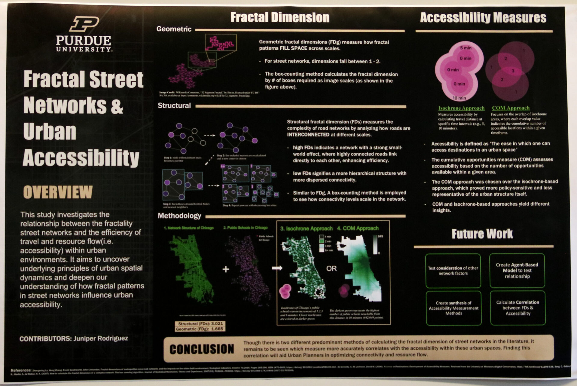
Fractal Street Networks & Urban Accessibility
Juniper Rodriguez
Undergraduate student
Anthropology, Artificial Intelligence

Evaluating the Use of LiDAR Traffic Data for Assessing Infrastructure
Andrew Thompson
Undergraduate student
Computer Science

Numerically Exploring the Dynamics, Statistics, and Predictability of Cold-Air Extremes Using an Idealized Mid-Latitude Temperature Variability Model
Rivkah Moshe
Graduate student
Mathematics

EpiSphere: Forecasting the Spread of Monkeypox Using Bayesian Optimization and ArcGIS
Shri Atluri
Undergraduate student
Computer Science

Exploring Protoplanetary Disks: What Dark Regions Tell Us About Planet Formation
Aydian Brown
Undergraduate student
Physics and Astronomy
Multimodal Remote Sensing Scene Classification with AI
Jinjin Cai
Ph.D. candidate, Computer and Information Technology
Purdue University
AI in Action: Enhancing Hamilton County’s Mapping and Geospatial Initiatives
Joan Keene
GIS Director
Hamilton County, IN
Philip Worrall
Project Consultant
Finding and Accessing Statewide GIS Data
Shaun Scholer
GIS Program Director
Indiana Geographic Information Office
Daniel Council
Geographic Information Outreach Coordinator
Indiana Geographic Information Office
University Partnering
Wes Avett
Account Executive, Education Practice
Databricks
Lightning Talk and Poster Award Winners
Congratulations to our 2024 winners! We are excited to celebrate you and your outstanding contributions to the field of GIS.
Recap
Purdue GIS Day 2024, with the theme of “Exploring GeoAI,” was a success and brought together over 180 students, academics, and industry professionals in a day filled with insightful talks, poster presentations, and networking opportunities. The event, hosted by Gang Shao, showcased the latest advancements in geospatial analysis and its applications across many disciplines.