a collage banner image with a circuit board, man using a computer mouse, rural village, false-color satellite image, and GPS antenna on a tripod

Purdue GIS Day Presentations

2025

Integrating AI across GIS

Gregory Brunner
Principal Data Scientist
Esri

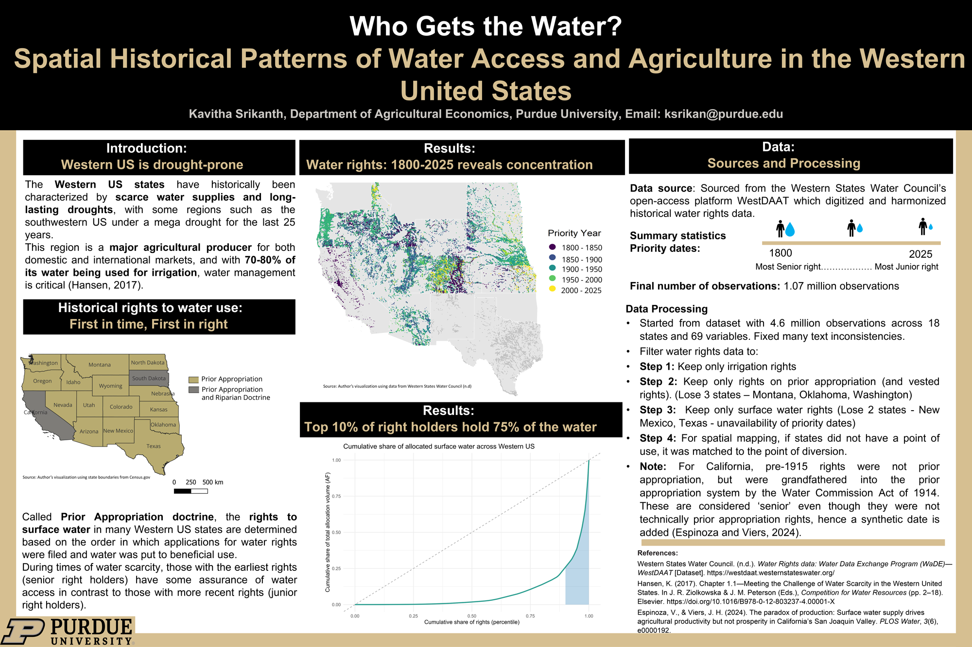
Who Gets the Water? Historical Patterns of Water Access and Agriculture in United States

Kavitha Srikanth
Graduate student

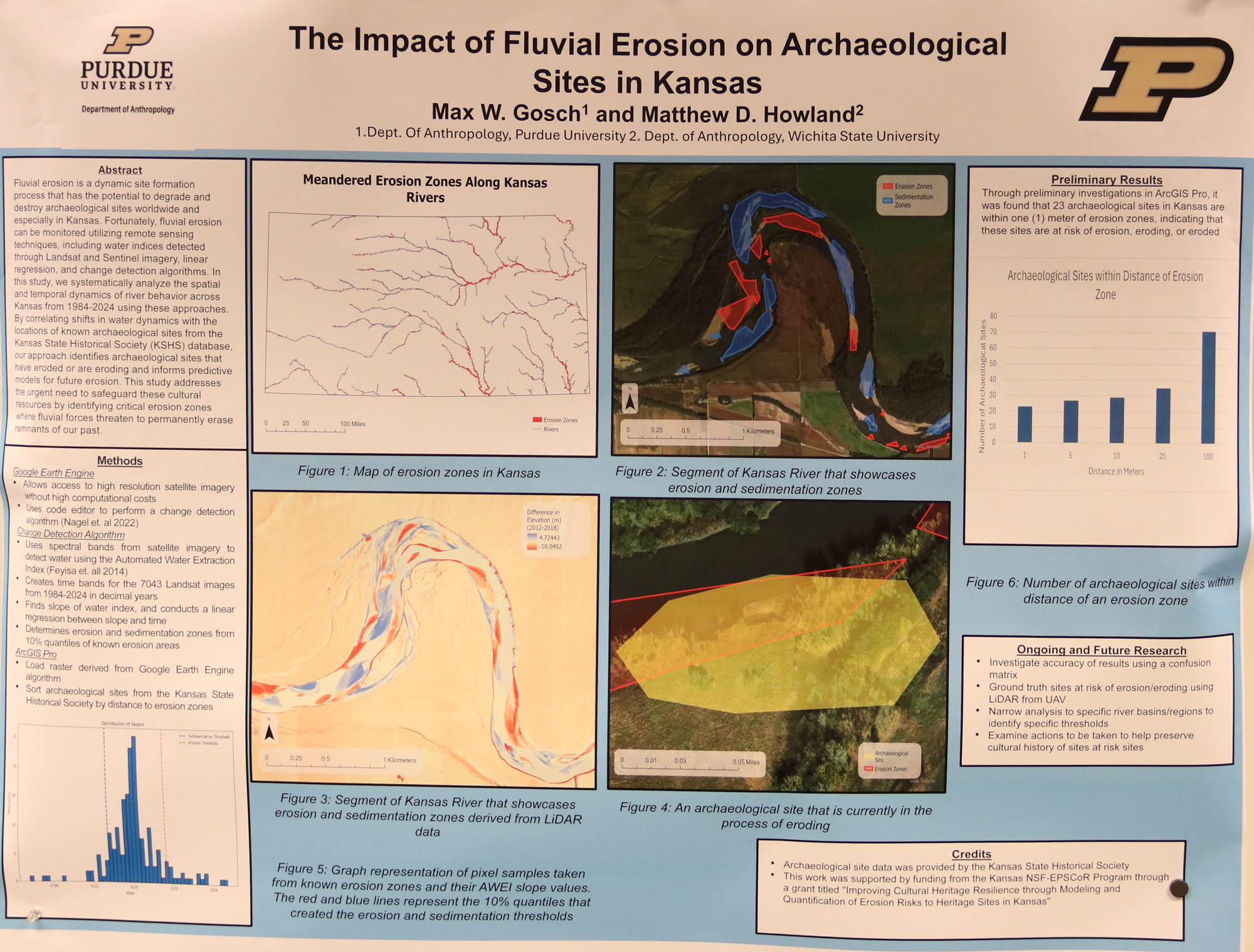
The Impact of Fluvial Erosion on Archaeological Sites

Max Gosch
Graduate student

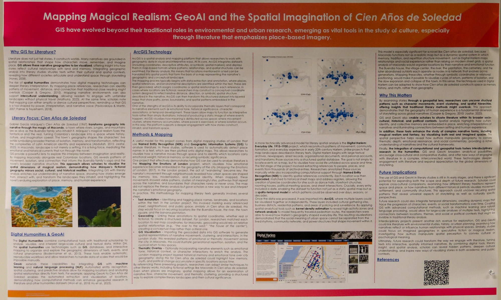
Mapping Magical Realism: GeoAI and the Spatial Imagination of Cien Años de Soledad

Sophia Pimentel
Undergraduate student

Poster of Public Participation Geographic Information Systems (PPGIS) in landscape domain.

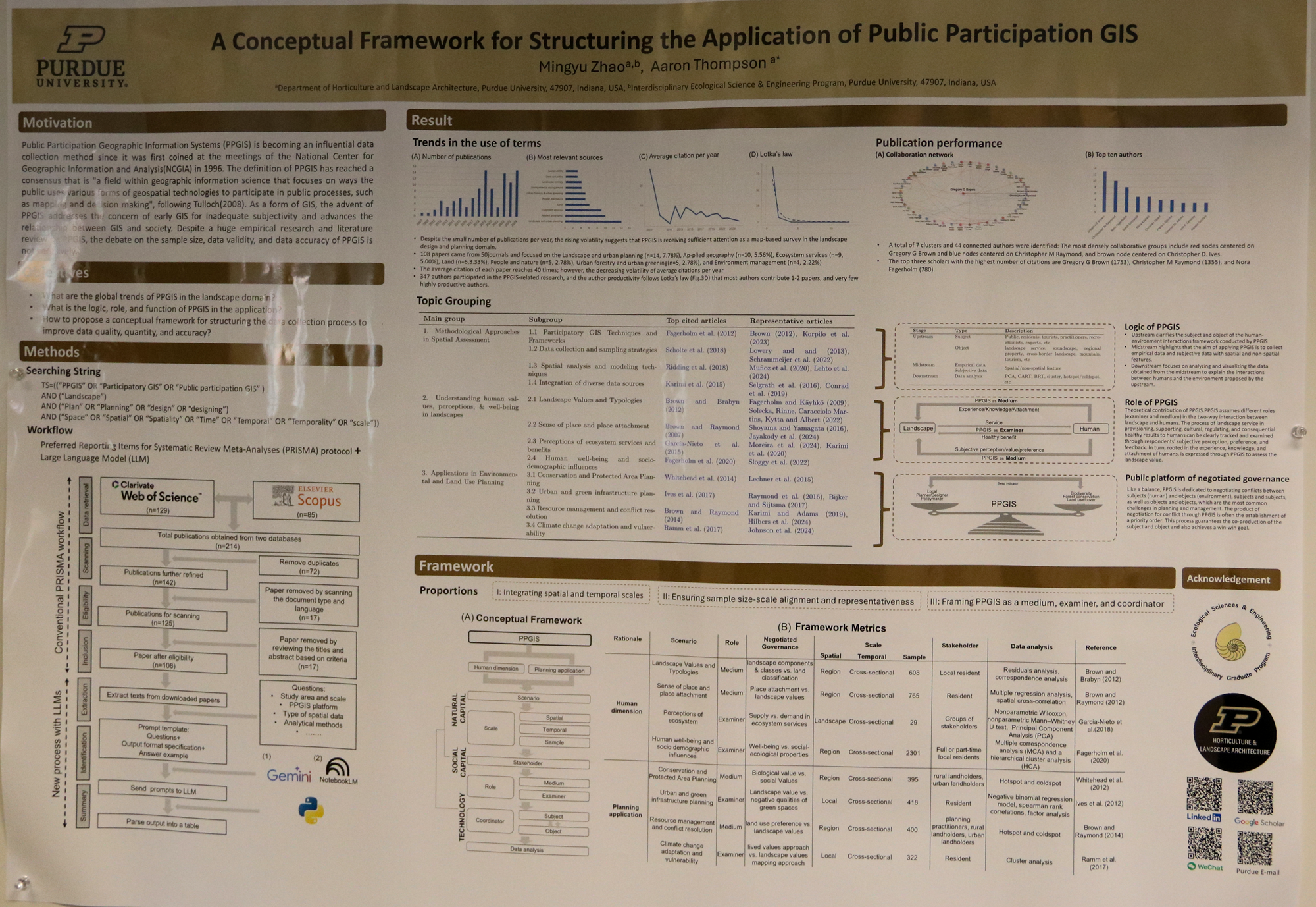
A Conceptual Framework for Structuring the Application of Public Participation GIS

Mingyu Zhao
Graduate student

Poster showing research on Multi-Disciplinary GeoAI, Climate Vulnerability Index (CVI), Remote Sensing, LULC, Old Oyo, Cultural Heritage, Adaptive Management

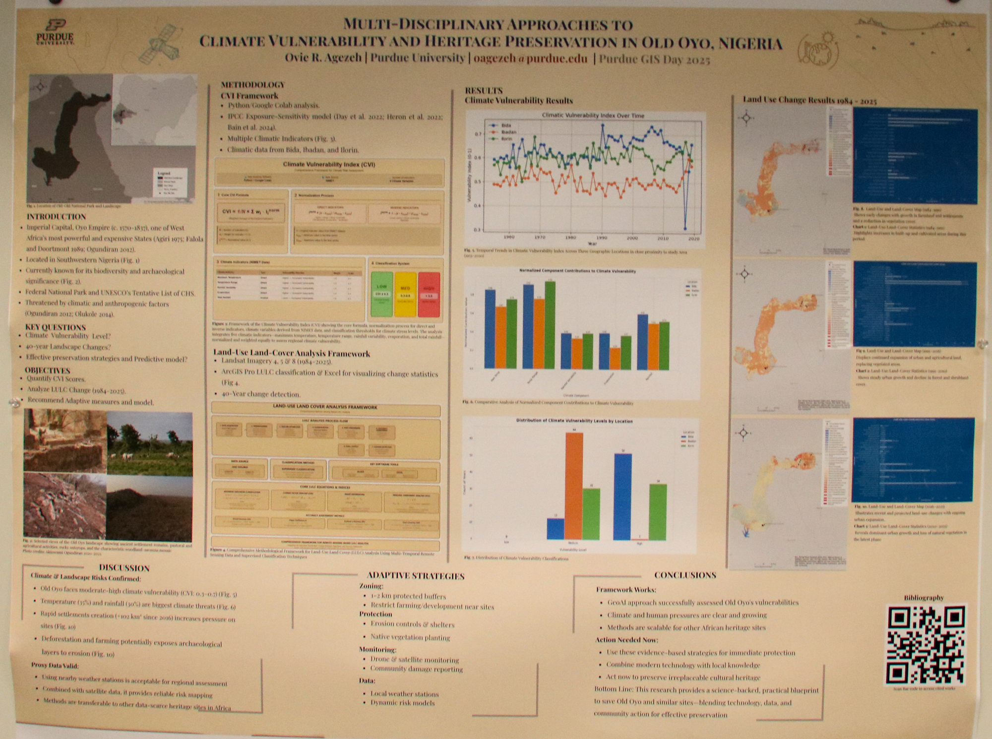
A Multi-Scalar GeoAI Approach: Integrating Climate Vulnerability and Remote Sensing for Sustainable Heritage Management at Old Oyo, Nigeria

Ovie Agezeh
Graduate student

Anthropology


Poster on Eidth Wharton's 1888 voyage on the steam yacht Vanadis and georeferences of her hourney

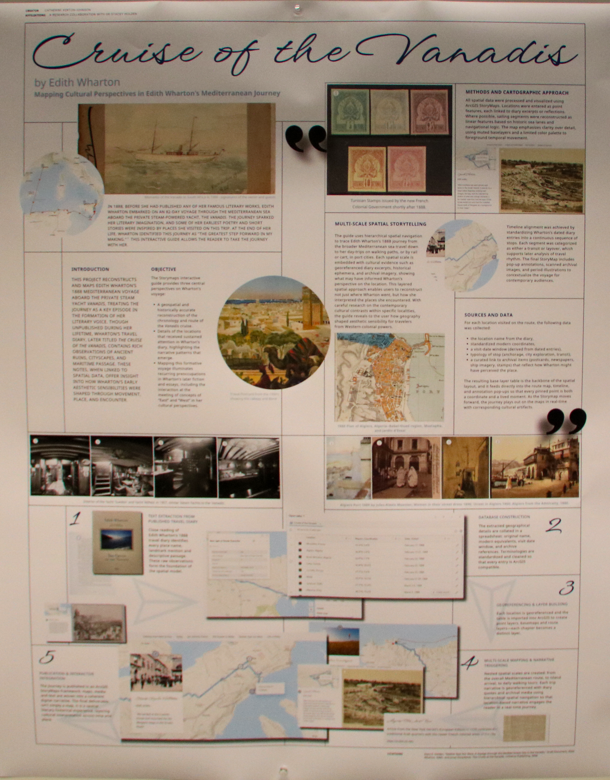
Cruise of the Vanadis: An Interactive Companion Guide

Catherine Kerton-Johnson
Graduate student


Poster on Indiana's access to relevant geospatial data for effective watershed

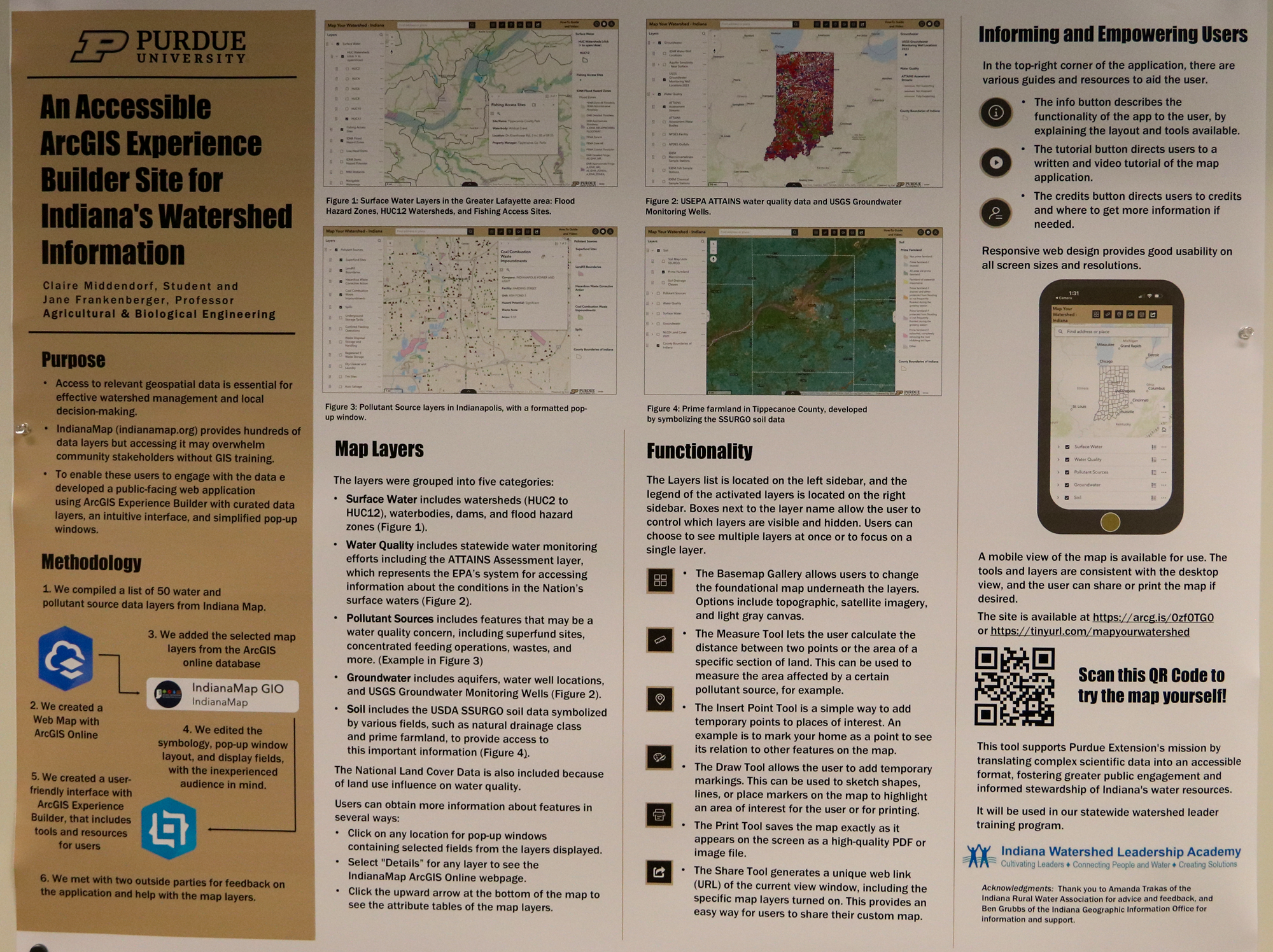
An Accessible ArcGIS Experience Builder Site for Indiana’s Watershed Information

Claire Middendorf
Undergraduate student

Environmental and Ecological Engineering


Poster on forest fragmentation from agriculture and urban expansion and how it alters canopy structure and ecosystem function

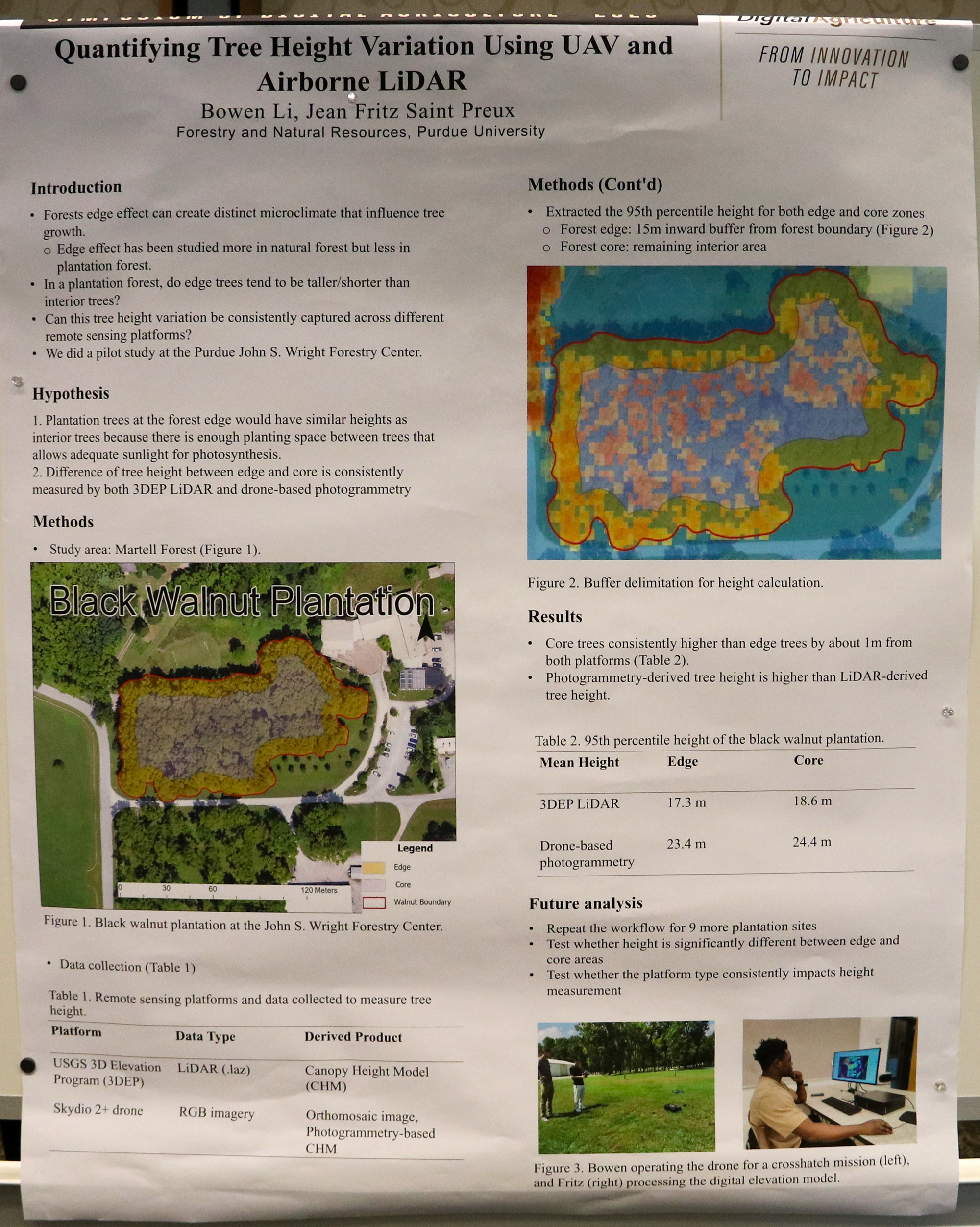
Quantifying Tree Height Variation Using UAV and Airborne Lidar

Jean Fritz Saint Preux
Graduate student


Poster on comparisons of conventional and resilient agriculture practices for long term changes in soil health

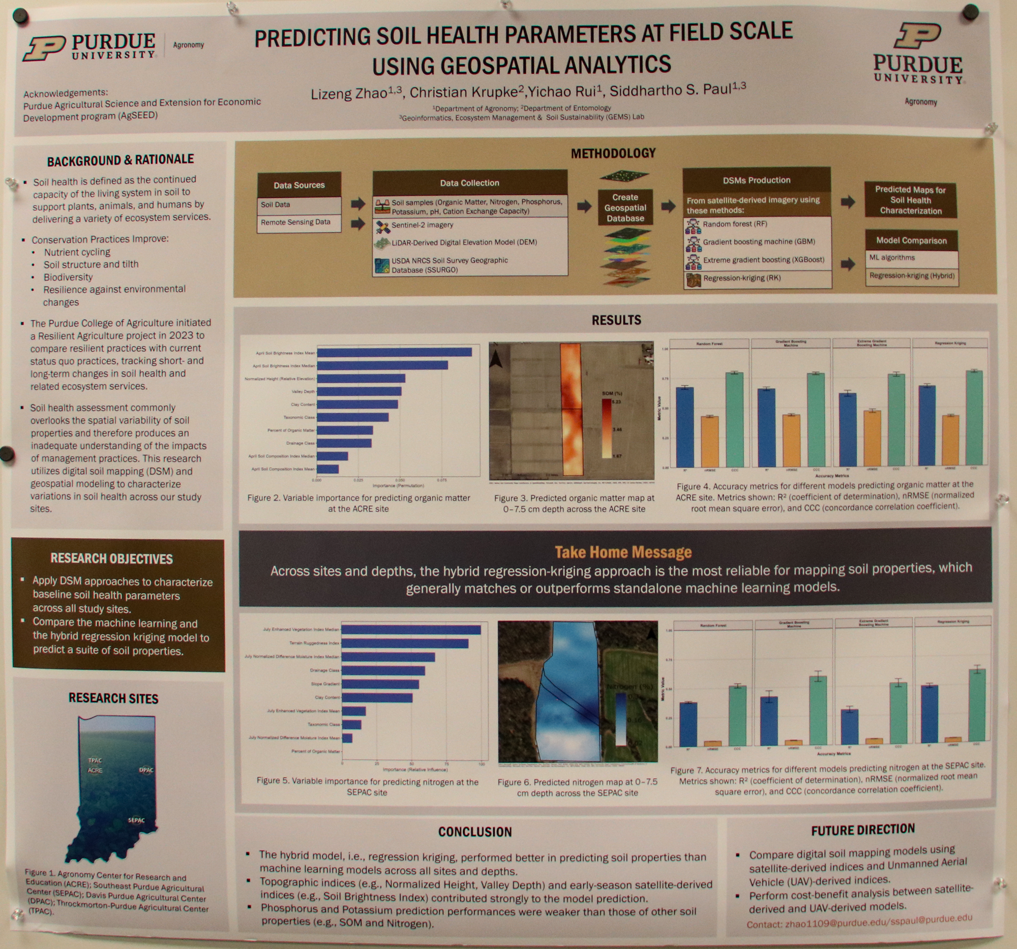
Predicting Soil Health Parameters at Field Scale Using Geospatial Analytics

Lizeng Zhao
Graduate student


Poster on geospatial models to identify and interpret long-term trends in Soil Organic Matter

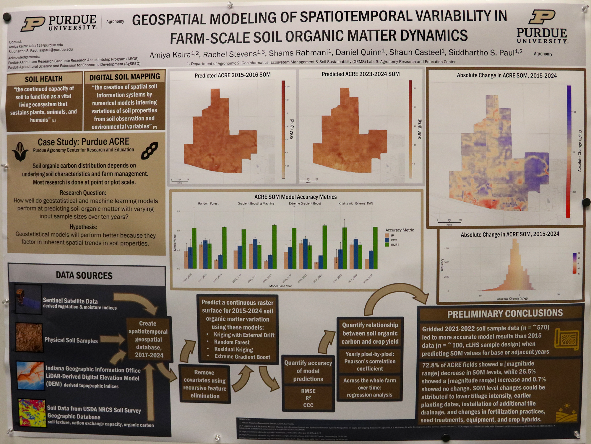
Geospatial Modeling of Spatiotemporal Variability in Farm-Scale Soil Organic Matter Dynamics

Amiyra Kalra
Graduate student

College of Agriculture


Poster on solar photovoltaic systems to support renewable energy development

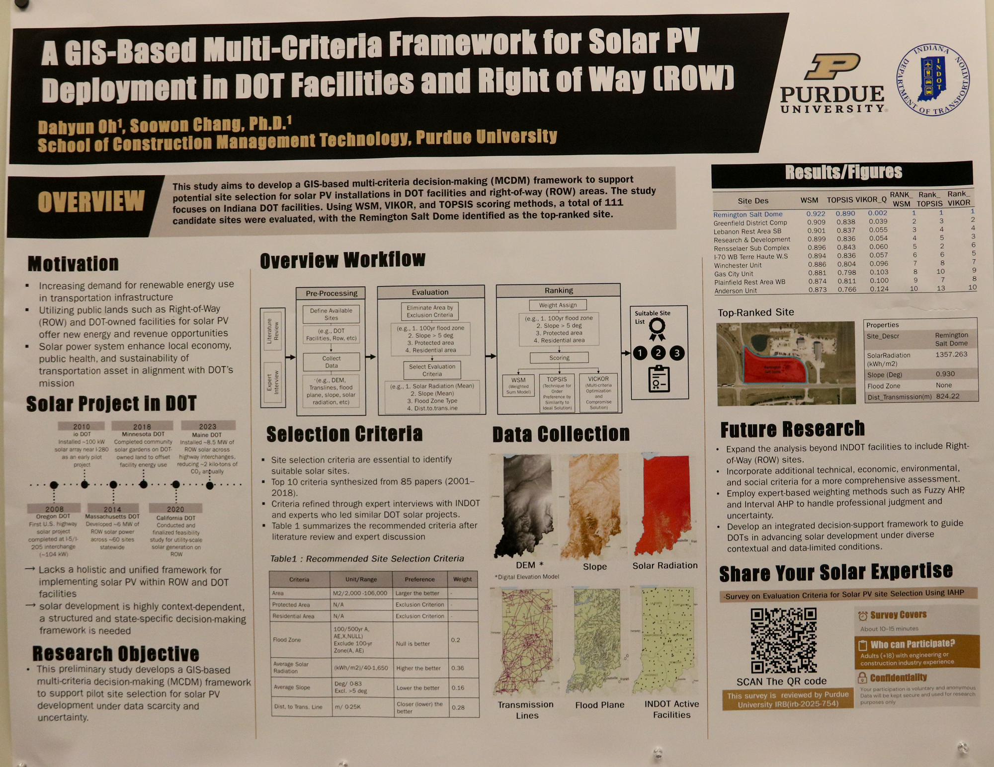
GIS-Based Multi-Criteria Decision Framework for Optimal Solar PV Site Selection in Transportation Infrastructure and Right-of-Way

Dahyun Oh
Graduate student

Construction Management Technology


Poster on understanding habitat distribution for effective wildlife management and conservation

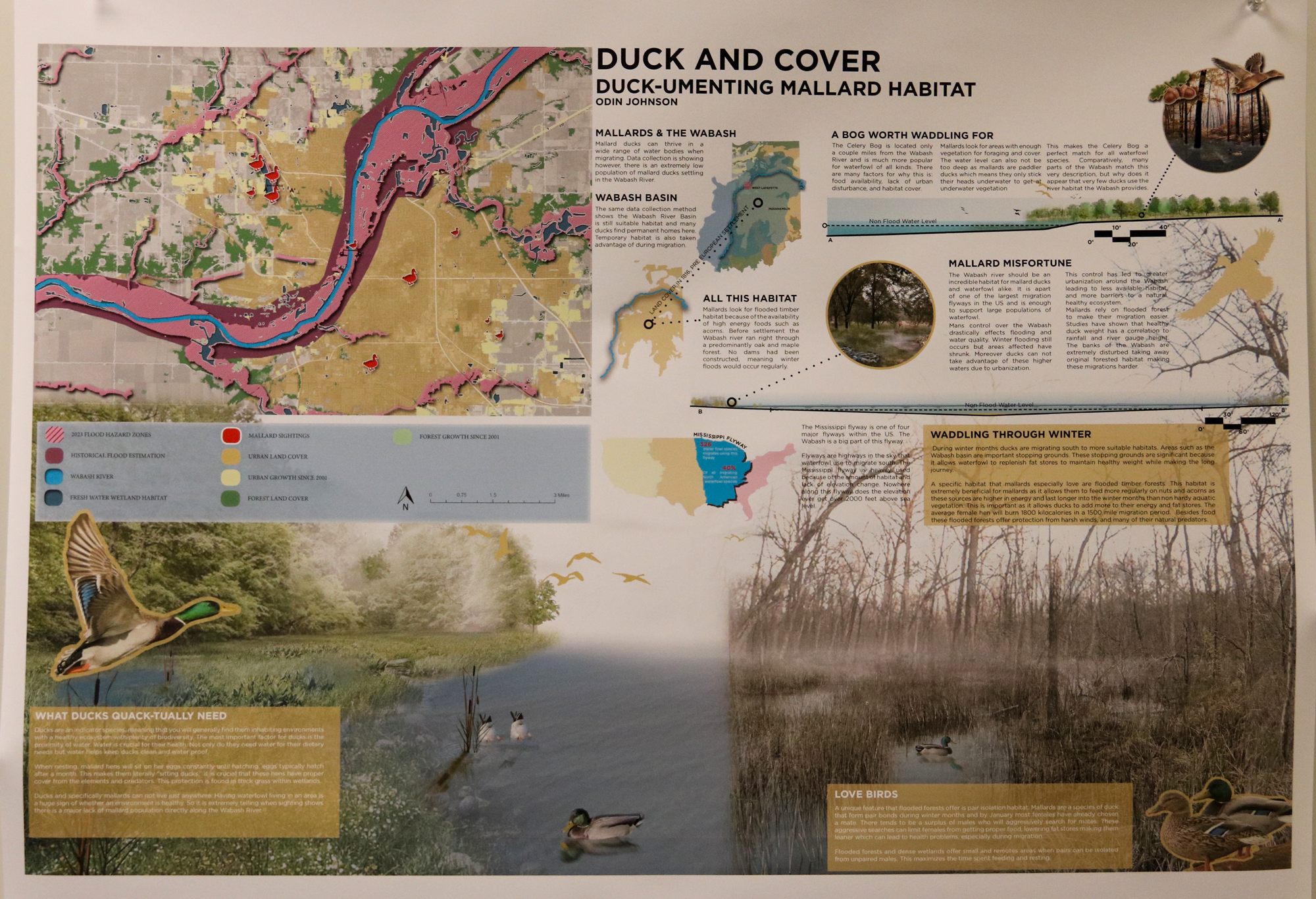
Duck and Cover – Duck-umenting Mallard Habitat

Odin Johnson
Undergraduate student


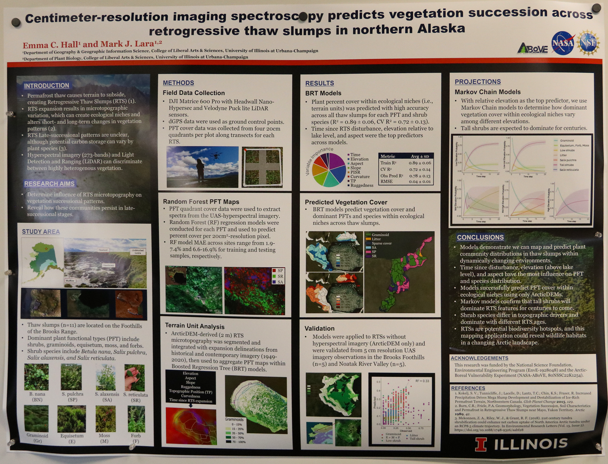
Centimeter-resolution imaging spectroscopy predicts vegetation succession across Retrogressive Thaw Slumps in northern Alaska

Emma Hall
Graduate student


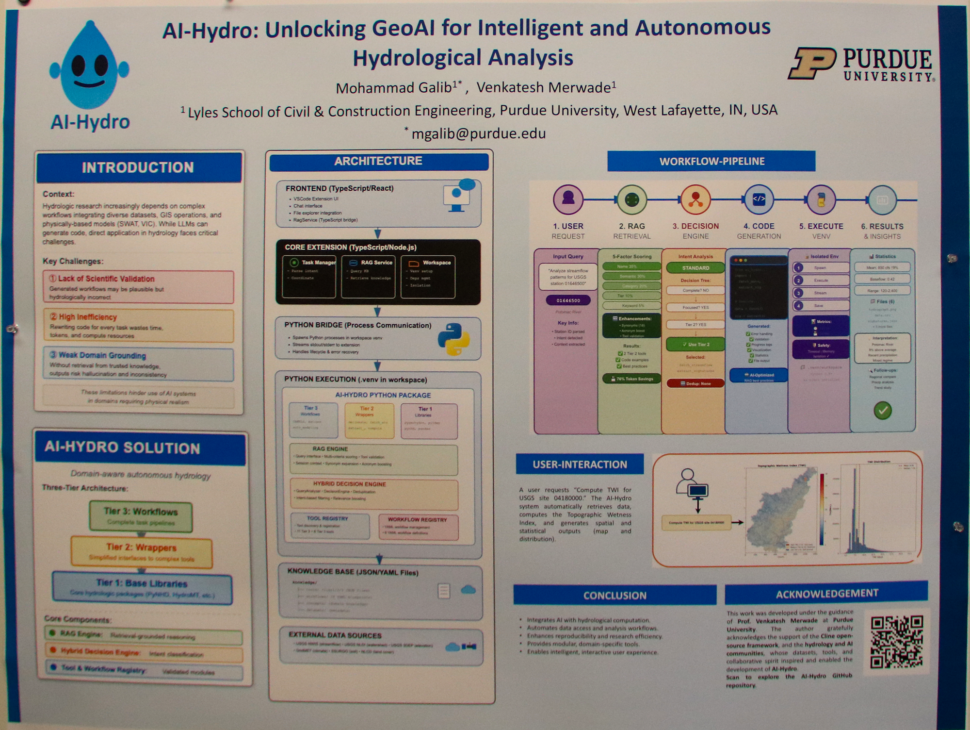
AI-Hydro: Unlocking GeoAI for Intelligent and Reproducible Hydrologic Data Science

Mohammad Galib
Graduate student


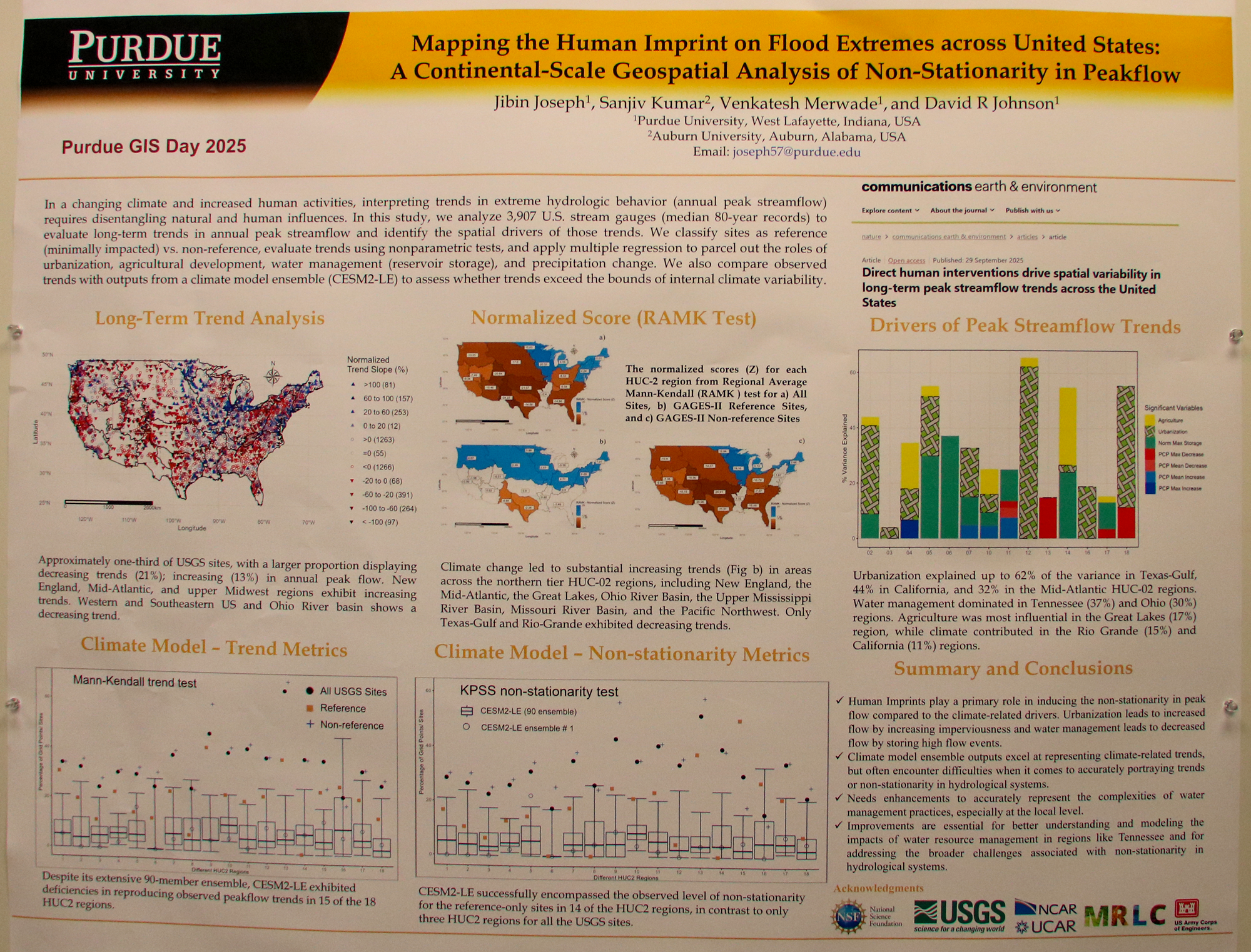
Mapping the Human Imprint on Flood Extremes across United States: A Continental-Scale Geospatial Analysis of Non-Stationarity in Peakflow

Joseph Jibin
Graduate student


Poster of julti-depth soil health across fields in Great Lakes Basin area

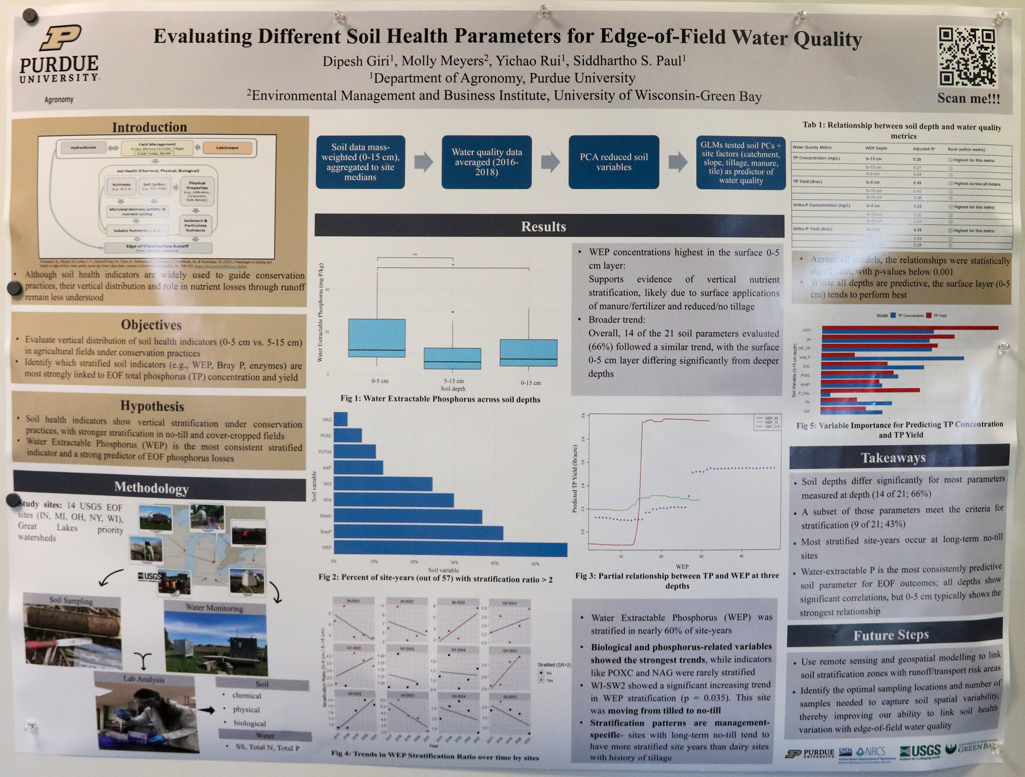
Evaluating Different Soil Health Parameters for Edge-of-Field Water Quality

Dipesh Giri
Graduate student


Poster on progress in developing machine learning-based models to predict storm surge

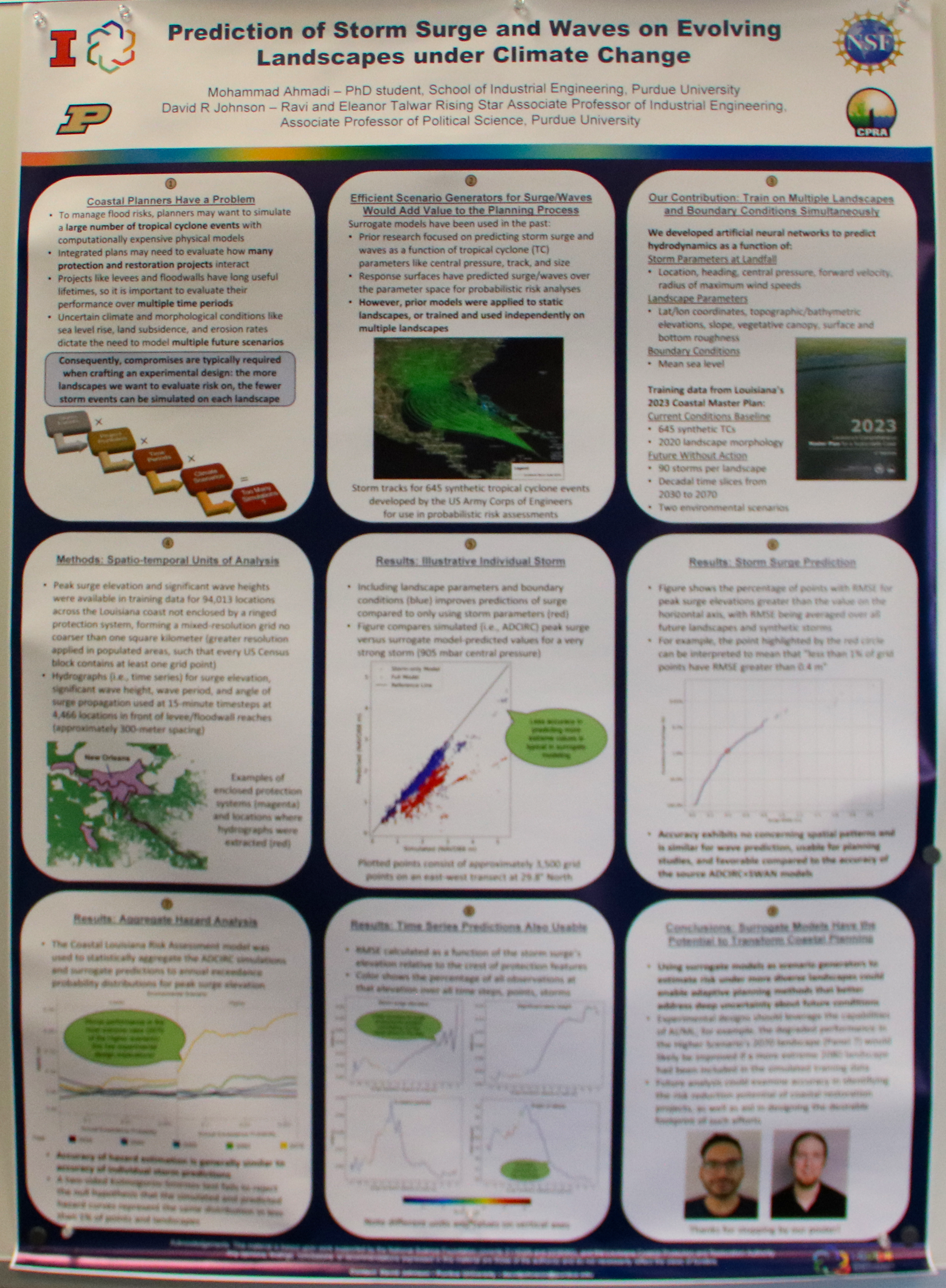
Prediction of Storm Surge and Waves on Evolving Landscapes under Climate Change

Mohammad Ahmadi
Graduate student


Poster of effective coastal management in the Great Lakes

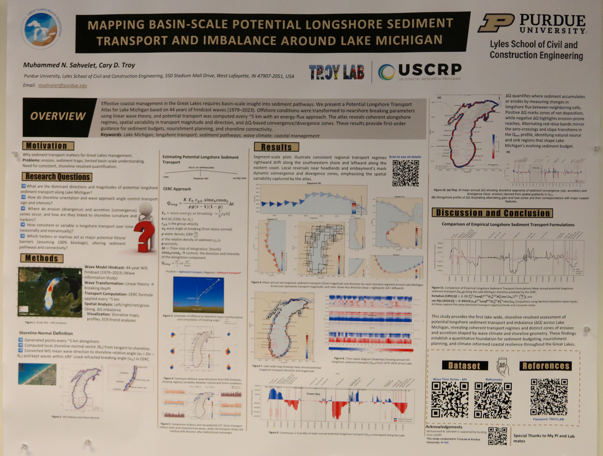
Mapping Basin-Scale Potential Alongshore Sediment Transport and Imbalance (ΔQ) Around Lake Michigan, 1979–2023

Muhammad N. Sahvelet
Graduate student


Poster of understanding the functioning of forest ecosystems inpreserving biodiversity and ecosystems services forests provide

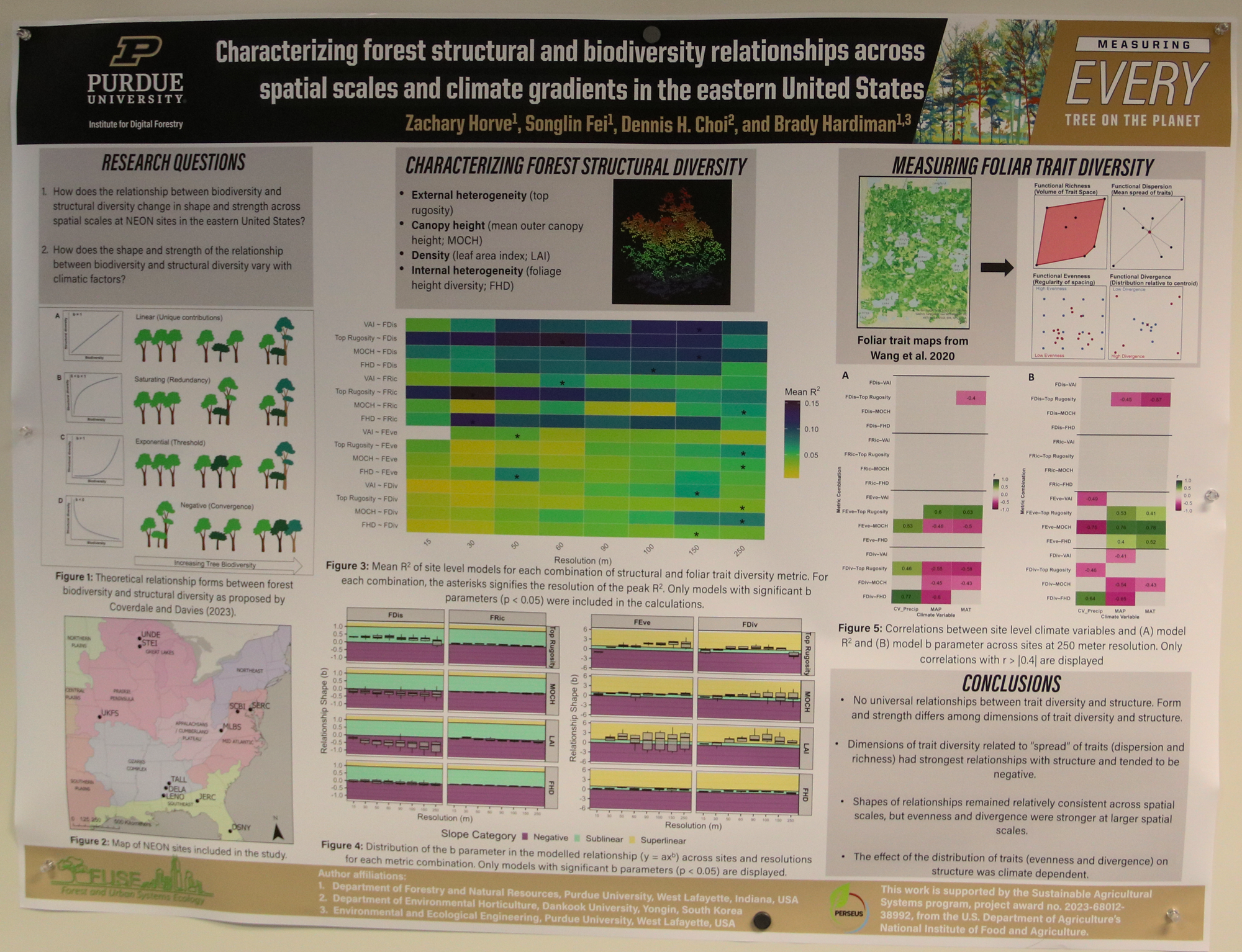
Characterizing forest structural and foliar trait diversity relationships across spatial scales and climate gradients in the eastern United States

Zack Horve
Graduate student


Poster of open-source GIS data identifying social and recovery risk-conscious emergency landing sites

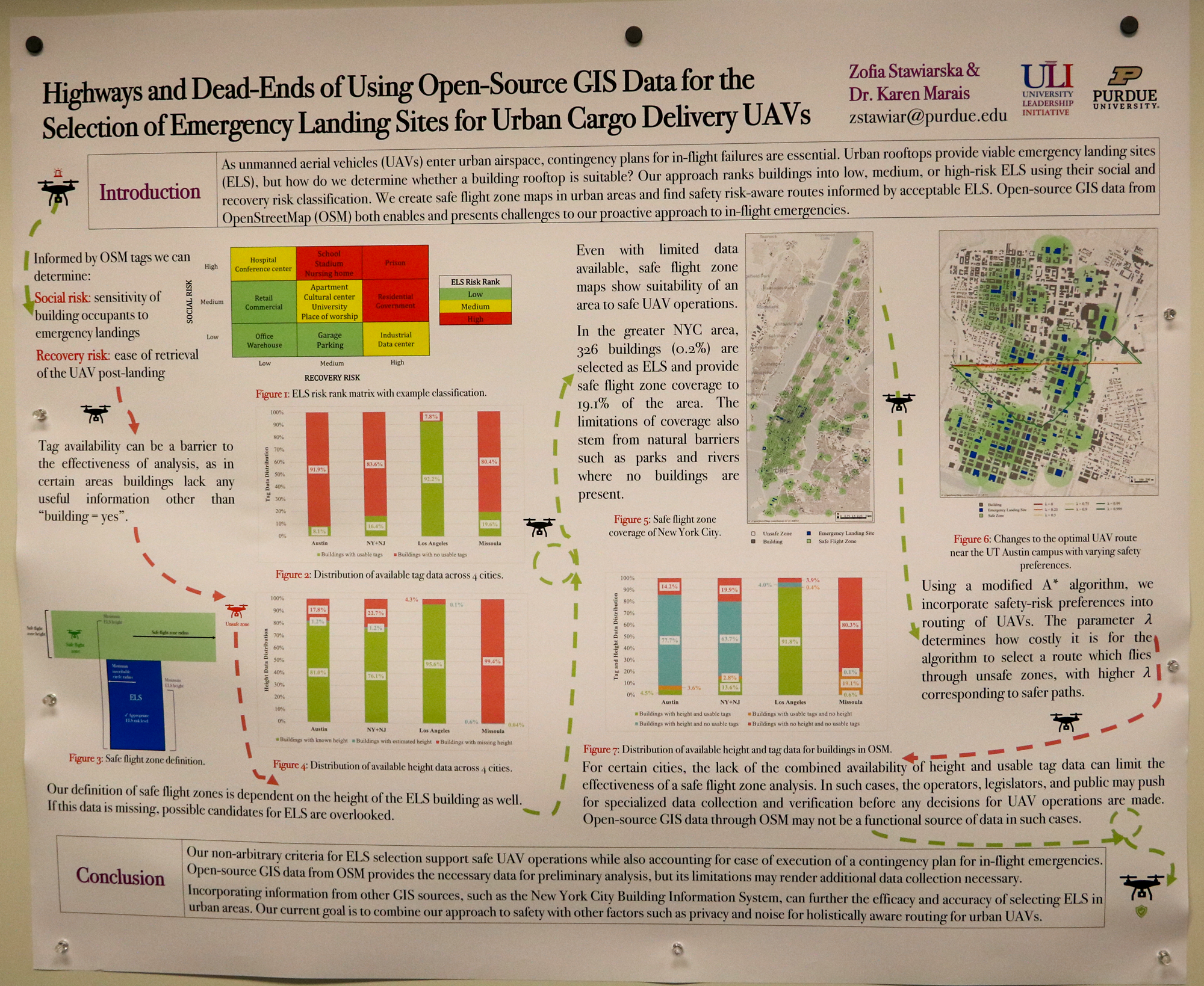
Highways and Dead-Ends of Using Open-Source GIS Data for the Selection of Emergency Landing Sites for Urban Cargo Delivery UAVs

Zofia Stawlarska
Graduate student


Poster of smart mapping implementations analyzing GeoAI extensions

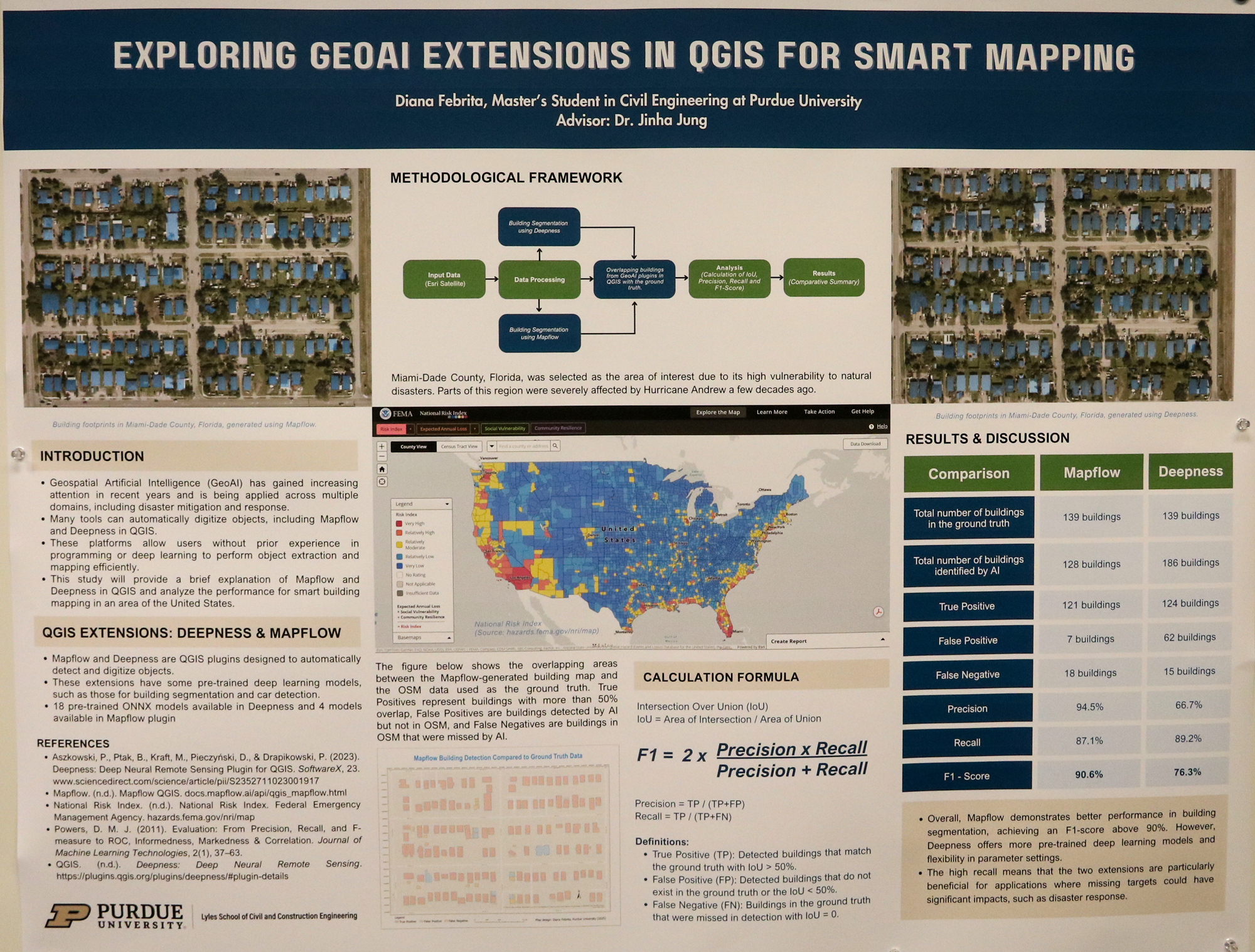
Exploring GeoAI Extensions in QGIS: A Comparative Analysis for Smart Mapping

Diana Febrita
Graduate student


Poster of research on Pacific Islands and climate change

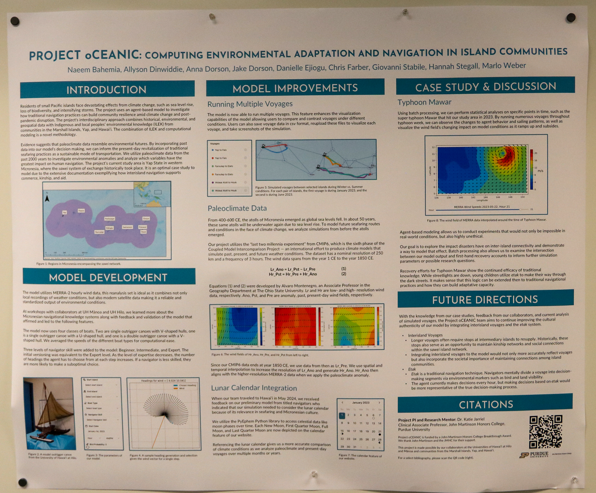
Project oCEANIC – Computing Environmental Adaptation and Navigation in Island Communities

Marlo Weber
Undergraduate student


Poster of feasibility of using Connected Vehicle-estimate International Roughness Index (IRI) for long-term statewide pavement monitoring on local Indiana roads.

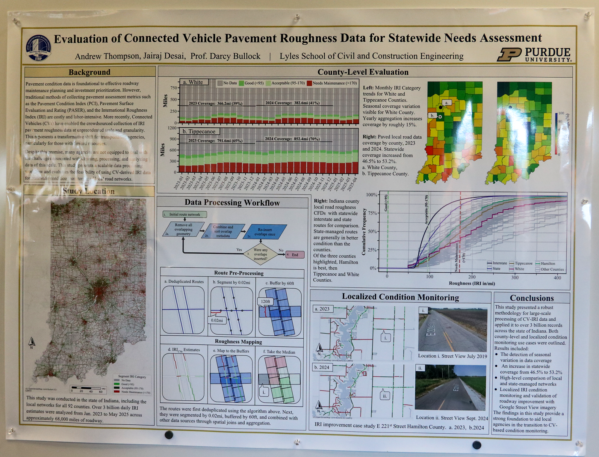
Evaluation of Connected Vehicle Pavement Roughness Data for Statewide Needs Assessment

Andrew Thompson
Undergraduate student


Poster of geospatial framework for estimating, quantifying and mapping last-mile package delivery demand for Unmanned Aerial Systems (UAS)

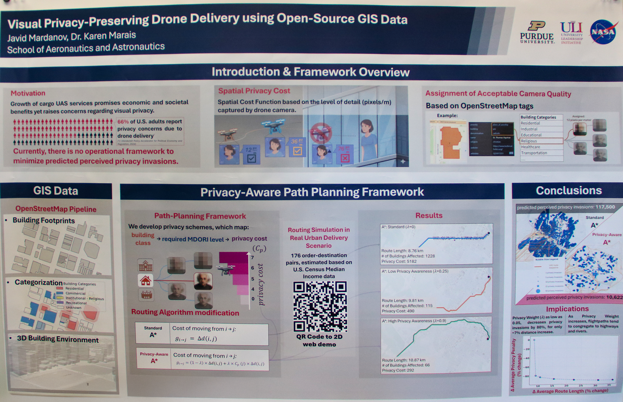
Visual Privacy-Preserving Drone Delivery using Open-Source GIS Data

Javid Mardanov
Graduate student


Poster of climate change altering geographic ranges of plant species

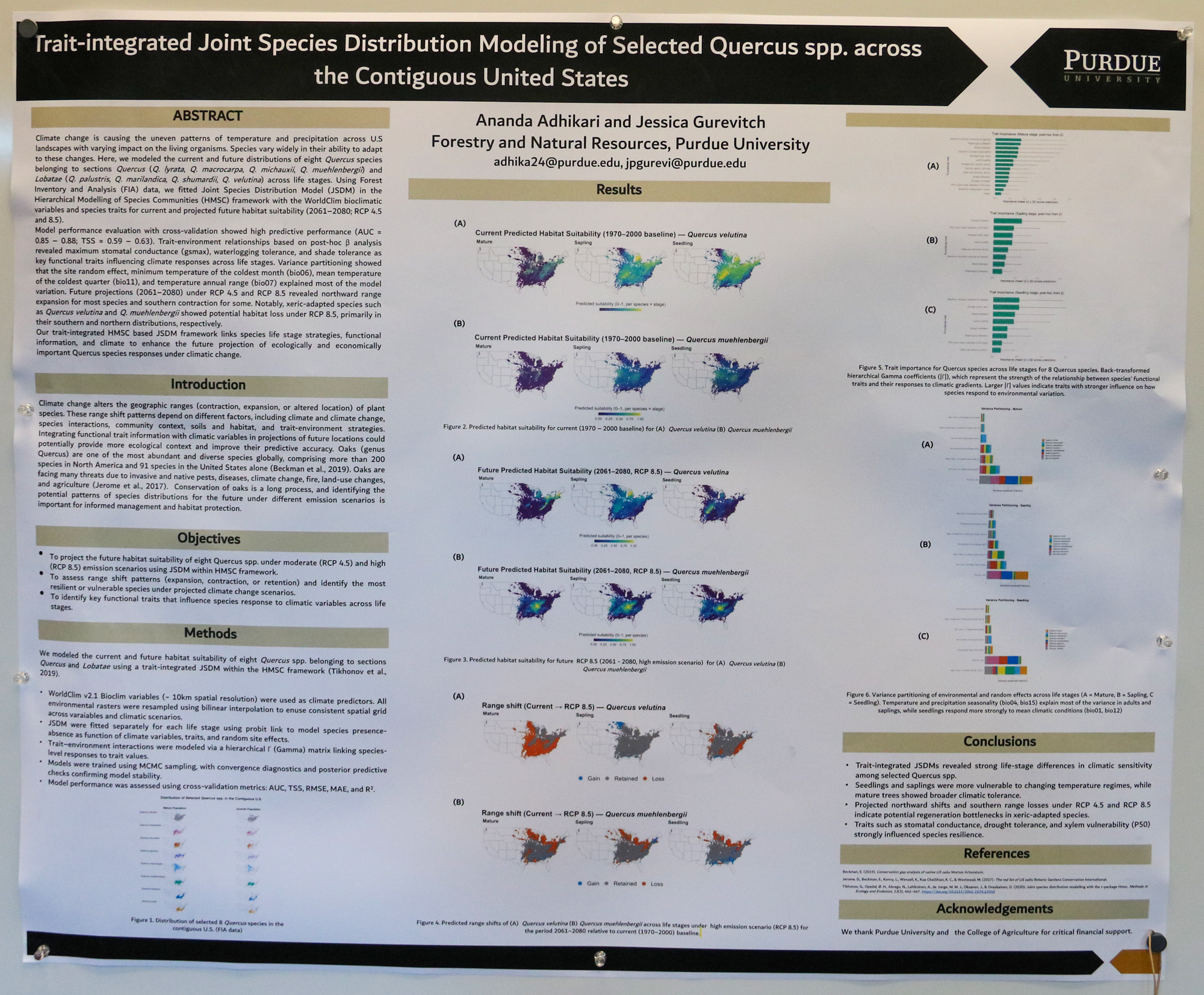
Trait-integrated Joint Species Distribution Modeling of Selected Quercus spp. across the Contiguous United States

Ananda Adhikari
Graduate student


Poster of mapping forest edges and cores across Indiana classifying edge zones by adjacent land use

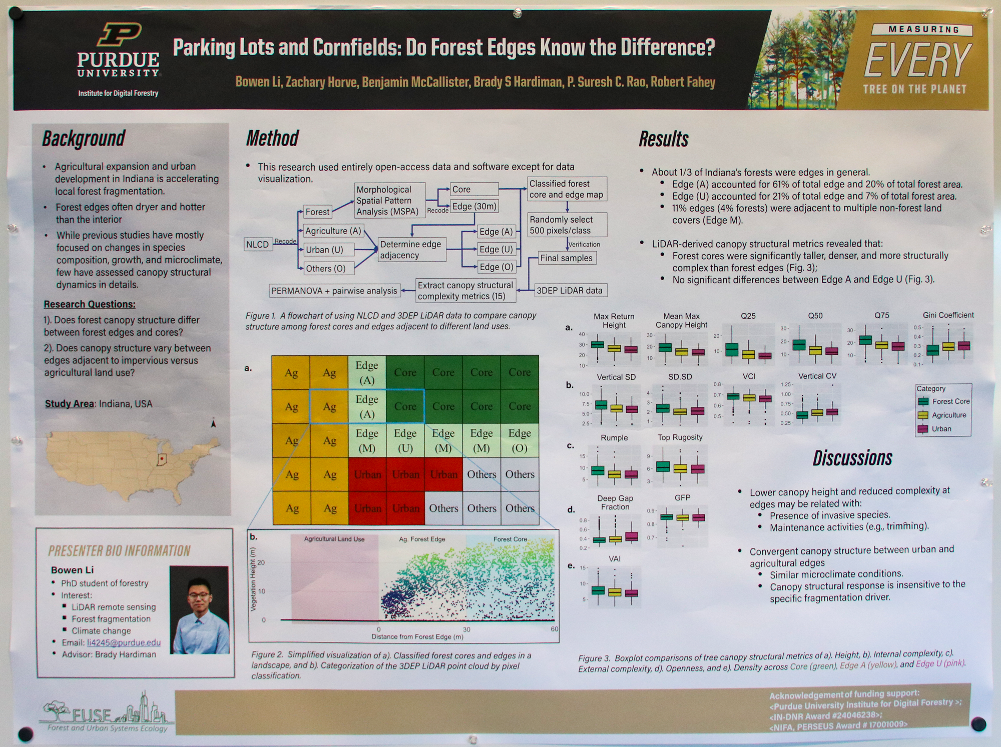
Parking Lots and Cornfields: Do Forest Edges Know the Difference?

Bowen Li
Graduate student


Poster on aerial fire detection and fire localization methods

Fire Evaluation Reconnaissance and Direction Analysis (FERDA)

Abhishek Kaushikkar
Undergraduate student


Poster capturing shoreliine dynamics and water quality processes in the Great Lakes

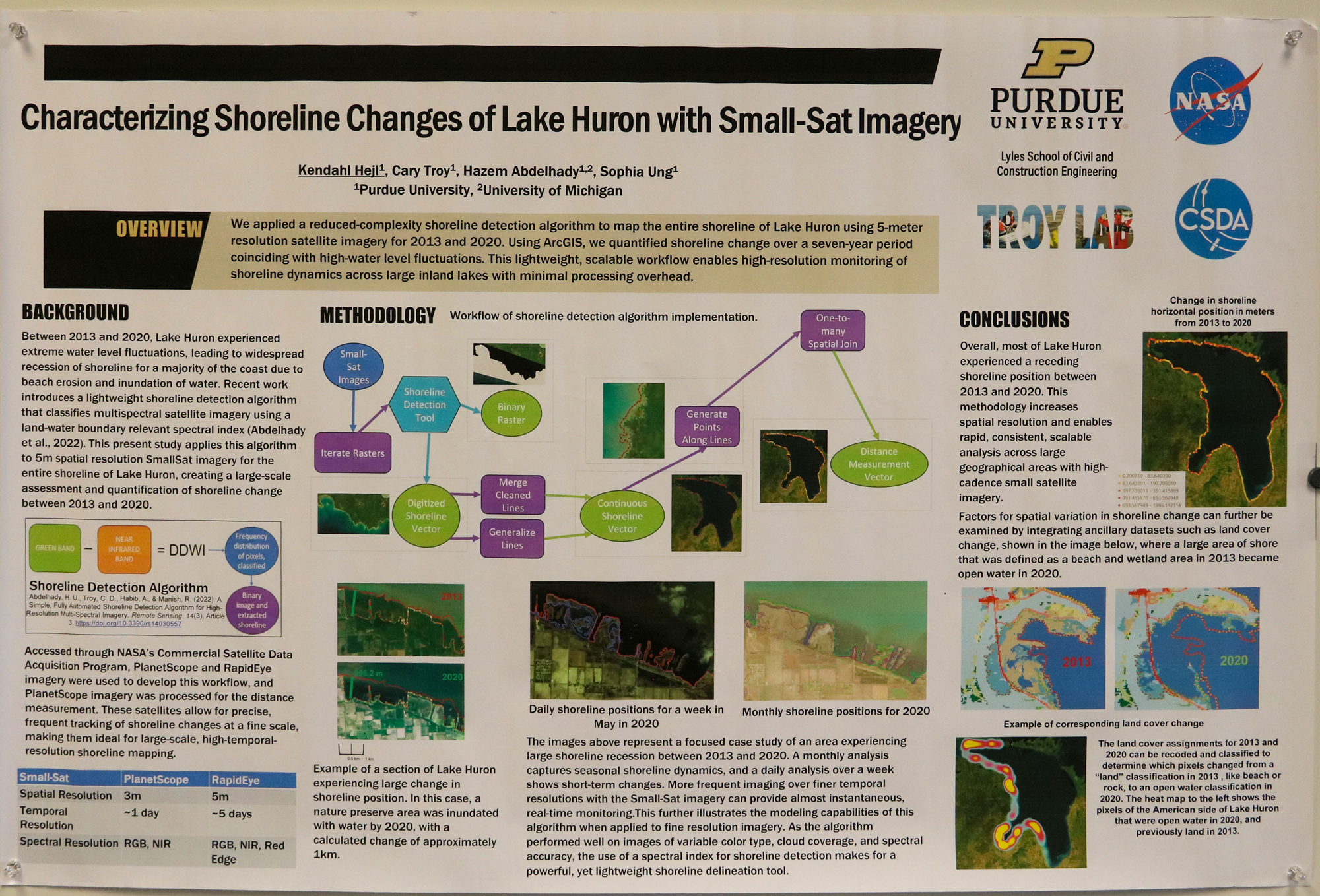
Characterizing Shoreline Changes of Lake Huron with Small-Sat Imagery

Kendahl Heji
Graduate student


Using GIS Across the Solar System to Unlock the Geologic History of Planets

Ali Bramson
Assistant Professor of Planetary Sciences
Purdue University

Data to Science: Open source ecosystem for GeoAI

Jinha Jung
Associate Professor of Civil Engineering, Geomatics
Purdue University

QGIS on HPC Clusters

Xiao Liu
Senior Research Software Engineer at the Rosen Center for Advanced Computing
Purdue University

Geospatial on AWS

David Conklin, Solutions Architect
Brian DeKemper, Enterprise Account Executive
Luke Coady, Solutions Architect
Amazon Web Services (AWS)

Hamilton County’s GeoAI Journey – 2024 Basemap Update Project Acquisition to Application

Joan Keene
GIS Director
Hamilton County, Indiana Government

GIS at the State of Indiana: The Role of the Indiana Geographic Information Office

Daniel Council, Geographic Information Outreach Coordinator
Shaun Scholer, GIS Technical Specialist (Programs and Outreach)
Indiana Geographic Information Office

2024

The Burgeoning AI Model Ecosystem and Its Impact on GIS

Gregory Brunner
Principal Data Scientist
Esri

Any-Scale Spatial Analysis on Databricks

Michael Johns
Lead Geospatial Product Specialist
Databricks

The Impacts of Training Data Spatial Resolution on Deep Learning

Christopher Ardohain
Graduate student
Forestry and Natural Resources

Exploring GeoAI Tools for Global Airport Ranking Analysis: A Comparative Study of Open-Source Geospatial Tools

Bortiorkor N T Alabi
Graduate student
Aviation and Transportation Technology

Stem Volume Measurement of Temperature Natural Forests from Mobile Mapping Point Clouds

Jinyuan Shao
Graduate student
Forestry and Natural Resources

Tree Trunk Detection and Species Identification

Yunmei Huang
Graduate student
Forestry and Natural Resources

Fire Mapping: Thermal Insights and Smart Indexing

Rahul Prabhu
Undergraduate student
Computer Science

Spatial Pattern of Air Quality and Power Plants in California: Mapping and Analysis Using GIS Approach

Diana Febrita
Graduate student
Geospatial Information Science

Inferring future distribution of three congeneric frogs using ecological niche modeling

Jong Yoon Jeon
Graduate student
Forestry and Natural Resources

Nonpoint Source Pollution Analysis Using ArcGIS Pro

Shrithik Sekar
Undergraduate student
Environmental and Ecological Engineering

“Tuned In or Fleeing”: Exploring the Intersections of Bird Migration and Outdoor Music Festivals in the Contiguous United States

Zhijie Zhou
Graduate student
Geography and GIS (University of Illinois Urbana-Champaign)

Application of geospatial intelligence in securing critical infrastructure

Joshua Gollapudi
Undergraduate student
Cybersecurity

GeoAI in Modern Warfare and Intelligence Gathering

Rhea Mukherjee
Undergraduate student
Computer Science

Geospatial Characterization of Landslides on the Moon using Radar Data

Santa Pérez-Cortés
Graduate student
Planetary Science/EAPS

How to (safely) land a robot on another planet: Mapping planetary missions from Venus to Mars

Margaret Deahn
Graduate student
Earth, Atmospheric, and Planetary Sciences

Mapping Surface Textures across the Medusae Fossae Formation of Mars

Christina Sowinski
Undergraduate student
Earth, Atmospheric, and Planetary Sciences

Mapping Cryptomaria on the Moon using Radar Data in ArcGIS Pro

Amanda Holmes
Undergraduate student
Geology and Geophysics

Archaeoscapes in Crisis: Towards a sustainable management of heritage in Nigeria

Archaeoscapes in Crisis: Towards a sustainable management of heritage in Nigeria

Ovie Agezeh
Graduate student
Anthropology

Examining the impact of local tobacco laws on sociodemographic differences in tobacco retailer density

Examining the impact of local tobacco laws on sociodemographic differences in tobacco retailer density

Bukola Usidame
Graduate student
Public Health

Advancing Remote Sensing Methods for Monitoring and Controlling Harmful Algal Blooms in Inland Waters of the North-Central United States

Advancing Remote Sensing Techniques for Monitoring and Mitigating Harmful Algae Blooms in North-Central United States Inland Waters

Nileshwari Yewle
Graduate student
Agricultural Biological Engineering

NIMBY and Geospatial Analysis: A Potential Path Forward

NIMBY and Geospatial Analysis: A Potential Path Forward

Jasper Neath
Graduate student
Political Science

Analyze Land Cover Change and Factors Influencing Wildlife Hazards at Airports

Analyzing Land Cover Changes and Influencing Factors on Wildlife Hazards at Airports: An Exploratory Study of Chicago O’Hare and Indianapolis International Airports

Haoruo Fu
Graduate student
School of Aviation and Transportation Technology

Navigating Conservation Planning through Social and Ecological Structures in Northwest Indiana

Navigating Conservation Planning through Social and Ecological Structures in Northwest Indiana

Grace Lentz
Graduate student
Horticulture and Landscape Architecture

Applying Deep Learning Models to Predict River Bathymetry for Hydrological and Hydraulic Simulations

Applying Deep Learning Models to Predict River Bathymetry for Hydrological and Hydraulic Simulations

Chung-Yuan Liang
Graduate student
Civil Engineering

Modeling suitable habitat for the Near Threatened Cerulean Warbler in the contiguous United States using ArcGIS and MaxENT

Modeling suitable habitat for the Near Threatened Setophaga cerulea in the contiguous United States using ArcGIS and MaxENT

Adebola Esther Adeniji
Graduate student
Forestry and Natural Resources

Introduction histories and climatic distribution patterns of three congeneric invasive anurans

Climatic Patterns of Establishment in Three Congeneric Amphibians

Andrew Mularo
Graduate student
Biological Sciences

Geographic Information System (GIS) 1 Application to Unmanned Aircraft System (UAS) Traffic Management (UTM) within the 2 National Airspace System (NAS)

Geographic Information System (GIS) Application to Unmanned Aircraft System (UAS) Traffic Management (UTM) within the National Airspace System (NAS)

Ryan Case
Graduate student
Aviation Technology & Management

ION Soil Health Census Map

Soil Health Census of Indiana’s Organic Agriculture

Ismael De Lara
Undergraduate student
Natural Resources and Environmental Science

Deep learning based bias-correction of PM2.5 concentration from GEOS-FP

Deep learning bias correction for PM2.5 forecasts from GEOS-FP

Michael Wang
Undergraduate student
Physics

Project oCEANIC (Computing Environmental Adaptation and Navigation in Island Communities)

Project oCEANIC: Computing Environmental Adaptation and Navigation in Island Communities

Marlo Weber
Undergraduate student
Computer Science

Fractal Street Networks & Urban Accessibility

Fractal Street Networks & Urban Accessibility

Juniper Rodriguez
Undergraduate student
Anthropology, Artificial Intelligence

Evaluating the Use of LiDAR Traffic Data for Assessing Infrastructure

Evaluating the Use of LiDAR Traffic Data for Assessing Infrastructure

Andrew Thompson
Undergraduate student
Computer Science

Numerically Exploring the Dynamics, Statistics, and Predictability of Cold-Air Extremes Using an Idealized Mid-Latitude Temperature Variability Model

Numerically Exploring the Dynamics, Statistics, and Predictability of Cold-Air Extremes Using an Idealized Mid-Latitude Temperature Variability Model

Rivkah Moshe
Graduate student
Mathematics

GIS Worldwide Disease Outbreak Prediction Model

EpiSphere: Forecasting the Spread of Monkeypox Using Bayesian Optimization and ArcGIS

Shri Atluri
Undergraduate student
Computer Science

Investigating Gap Depth and Mergence in Protoplanetary Disks with Multiple Planetary Bodies

Exploring Protoplanetary Disks: What Dark Regions Tell Us About Planet Formation

Aydian Brown
Undergraduate student
Physics and Astronomy

Multimodal Remote Sensing Scene Classification with AI

Jinjin Cai
Ph.D. candidate, Computer and Information Technology
Purdue University

AI in Action: Enhancing Hamilton County’s Mapping and Geospatial Initiatives

Joan Keene
GIS Director
Hamilton County, IN

Philip Worrall
Project Consultant

Finding and Accessing Statewide GIS Data

Shaun Scholer
GIS Program Director
Indiana Geographic Information Office

Daniel Council
Geographic Information Outreach Coordinator
Indiana Geographic Information Office

University Partnering

Wes Avett
Account Executive, Education Practice
Databricks