
Purdue GIS Day 2025: Unlocking GeoAI Data and Tools
Thursday, November 6, 2025 in Stewart Center
Purdue GIS Day 2025, with the theme of “Unlocking GeoAI Data and Tools,” was a success and brought together over 200 students, academics, and industry professionals in a day filled with insightful talks, poster presentations, and networking opportunities. The event, hosted by Gang Shao, showcased the latest advancements in geospatial analysis and its applications across many disciplines.
Purdue GIS Day 2025 was sponsored by:


Exhibitors
- Amazon Web Services
- Cultivate Geospatial Solutions
- Ecopia AI
- Environmental Systems Research Institute, Inc.
- Indiana Geographic Information Office
- Purdue Institute for Digital and Advanced Agricultural Systems
- Purdue Institute for Digital Forestry
- Purdue Libraries and School of Information Studies
Agenda
View the agenda of the 2025 conference.
Speakers

Ali Bramson
Assistant Professor of Planetary Sciences, Purdue University
Dr. Bramson uses remote sensing observations, such as those acquired with radar and imaging systems onboard spacecraft, to understand the planets in our solar system. She often combines observational analyses with theoretical modeling, field work at terrestrial analog sites, and experimental studies. She works with spacecraft operations to target sites for new data acquisition and is also involved in projects to plan for the future of robotic spacecraft missions and human exploration to the Moon, Mars, and beyond. Dr. Bramson joined the faculty in Purdue’s Department of Earth, Atmospheric, and Planetary Sciences in 2020. Prior to that, she was at the University of Arizona’s Lunar and Planetary Laboratory, where she received her M.S. and Ph. D. in planetary sciences with a minor in geosciences. She received her BS from the University of Wisconsin-Madison, double-majoring in physics and astronomy and obtaining a certificate in computer science.

Gregory Brunner
Principal Data Scientist, Esri
Brunner is an experienced scientist, award-winning professor, and principal data scientist at Esri, the global leader in GIS software, location intelligence, and mapping. Through his vision and leadership, Brunner has helped organizations worldwide manage, disseminate, and analyze large volumes of imagery to support diverse missions and solve complex problems. His current work focuses on developing custom AI and computer vision-based spatial analysis tools to extract and attribute features from imagery, as well as exploring extended reality (XR) applications and integrating 3D GIS data into XR environments. A passionate educator, Brunner served as an adjunct professor at Saint Louis University from 2017 to 2022, earning the 2019 Excellence in Adjunct Teaching award. He has authored multiple lesson paths on Esri’s ArcGIS Learn platform to teach users how to apply the ArcGIS API for Python in data science.
Marianne Cardwell
Geographic Information Officer, State of Indiana
Cardwell is the geographic information officer for the State of Indiana. She holds a B.A. in Geography from Michigan State University and an M.S. in Geographic and Cartographic Sciences from George Mason University. She has been a GIS Analyst, Developer, Manager, and Director throughout her 25 years as a GIS consultant prior to joining the Indiana Geographic Information Office.

Luke Coady
Solutions Architect, Amazon Web Services (AWS)
Coady is a solutions architect at AWS with over 23 years of combined experience in technology. His experience spans both traditional on-premises infrastructure and modern cloud architectures, making him particularly adept at guiding educational institutions through their digital transformation journeys.

David Conklin
Solutions Architect, Amazon Web Services (AWS)
Conklin is a solutions architect who joined Amazon Web Services (AWS) in 2022. He is passionate about Geographic Information Systems (GIS), Cloud Geospatial, and Big Data. Outside of work, Conklin enjoys traveling, playing soccer, and learning about the latest trends and applications in geospatial and AI.
Daniel Council
Geographic Information Outreach Coordinator, Indiana Geographic Information Office (IGIO)
Council is the newest geographic information outreach coordinator for the Indiana Geographic Information Office (IGIO), working closely across the northern region of Indiana to foster relationships in the GIS community. He received his Bachelor’s in Geography from Ball State University and his Master’s in Spatial Analysis from Toronto Metropolitan University. Council has a diverse GIS background spanning multiple positions, including research on crowdsourced mapping, county government, and geodemographic analysis for marketing purposes.

Brian DeKemper
Enterprise Account Executive, Amazon Web Services (AWS)
DeKemper is an enterprise account executive at AWS, supporting research university customers in the Great Lakes region. He’s spent over two decades working in technology and services companies that focus on the higher education market. Outside of work, he enjoys skiing and traveling with his family.

Songlin Fei
Professor and iDiF Director for Forestry & Natural Resources | Purdue University
Dr. Fei is the chair of remote sensing and director of the Institute for Digital Forestry, and is a quantitative ecologist specializing in forest ecology, invasion ecology, and geospatial analytics, and joined Purdue faculty in 2011. He received his Ph. D. from Penn State University.

Jinha Jung
Associate Professor of Civil Engineering, Geomatics, Purdue University
Dr. Jung is an associate professor in the School of Civil Engineering at Purdue University. He received his Ph.D. degree in Geomatics – Civil Engineering, specializing in Computational Science & Engineering at Purdue University in 2011. He worked as a postdoctoral research associate at the University of Illinois at Chicago & Purdue University and worked as a faculty at Texas A&M University-Corpus Christi from 2014 until he joined Purdue University in 2019. Dr. Jung is noted for his work in 1) the development of UAS based High Throughput Phenotyping system for agriculture applications, 2) developing algorithms to process UAS data for feature extraction, 3) data fusion of hyperspectral and full-waveform LiDAR data, 4) vegetation structural analysis using LiDAR data, 5) high-performance computing for advanced remote sensing algorithm development, and 6) WebGIS software development using Free and Open Source Software (FOSS).

Joan Keene
GIS Director, Hamilton County, Indiana Government
Keene is the GIS Director for Hamilton County, Indiana, whose responsibilities include ensuring the availability and accessibility of geospatial services and data for end users, managing the annual acquisition of the county’s orthoimagery program, and collaborating with the state, Hamilton County municipalities, and regional agencies on various initiatives. Keene served as the Indiana Geographic Information Council (IGIC) President during 2022–2023 and represented the Large County Government on the IGIC Board of Directors during 2018–2024.

Nicole Kong
Professor of GIS and Associate Dean for Research for Libraries and School of Information Studies, Purdue University
Dr. Kong is associate dean for research and professor of GIS at Purdue University Libraries and School of Information Studies, where she leads research on geospatial data discovery, integration, and visualization. She has published extensively on GIS applications in environmental monitoring, digital humanities, and spatial analysis, and has received awards including the Map and Geospatial Information Round Table (MAGIRT) Honors Award and Esri Special Achievement in GIS Award.

Ian Lindsay
Associate Professor of Anthropology, Purdue University
Dr. Lindsay is an anthropological archaeologist studying the origins of complex societies in the South Caucasus. He co-directs an international collaborative expedition called Project ArAGATS, together with scholars and co-directors from the Institute of Archaeology and Ethnography of the Republic of Armenia, Cornell University, NYU/Institute for the Study of the Ancient World, and the University of Illinois at Urbana-Champaign. His interests also extend to the use of remote sensing, GIS, and photogrammetric techniques and a critical engagement with how these new digital data collections methods are impacting archaeological practice, particularly in post-colonial contexts. Many of the data sets and methods we employ provide excellent opportunities for student participation in the field and laboratory.

Xiao Liu
Senior Research Software Engineer, Rosen Center for Advanced Computing, Purdue University
Liu is a senior research software engineer at the Rosen Center for Advanced Computing, Purdue University. With a strong foundation in Computational Geosciences, Xiao brings broad expertise in remote sensing, GIS, ML/AI, HPC, and hydrologic modeling.

Thomas Peck
Senior Associate, Ecopia AI
Peck serves as a senior associate at Ecopia AI, leading Ecopia’s U.S. state land cover and environmental programs. In this role, he oversees large-scale geospatial data initiatives across all 50 states, ensuring the integration of high-resolution land cover data into critical environmental and governmental applications. Peck holds an Honor’s of Business Administration from the Richard Ivey School of Business and a Bachelor’s of Urban Development and Geography from the University of Western Ontario.

Shaun Scholer
GIS Program Director, State of Indiana
Scholer leads the imagery and elevation programs for the Indiana Geographic Information Office (IGIO). He received his bachelor’s degree in aviation from ISU in 1993 and a master’s degree in Geography with an emphasis on GIS and Remote sensing from ISU in 1995. During his 28-year career in GIS, he worked to foster partnerships to identify needs, determine effective GIS policy-level decisions, and implement practical, effective GIS initiatives. Shaun has also served in multiple leadership roles within IGIC.
Presentations
Integrating AI across GIS
Gregory Brunner
Principal Data Scientist
Esri
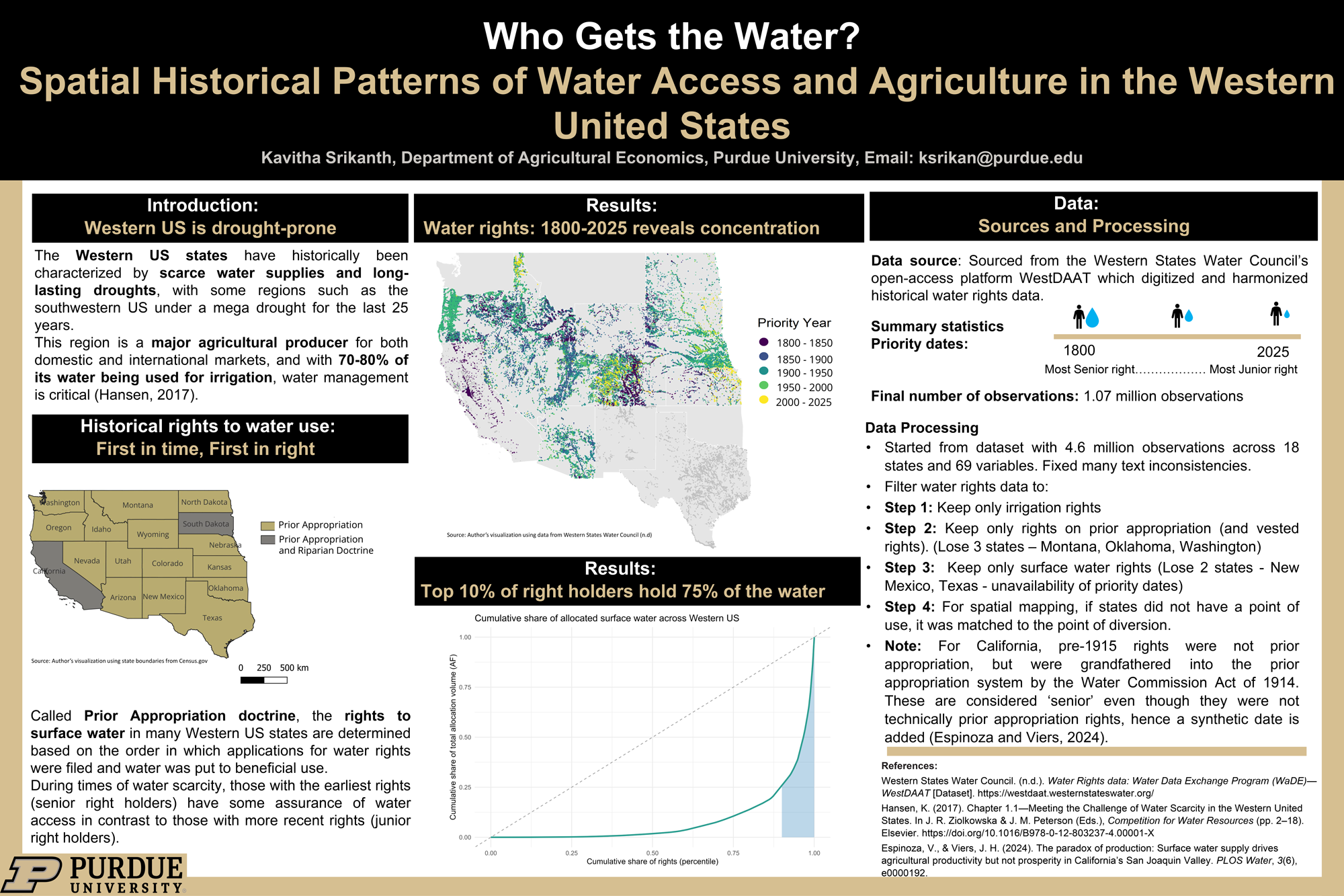
Who Gets the Water? Historical Patterns of Water Access and Agriculture in United States
Kavitha Srikanth
Graduate student
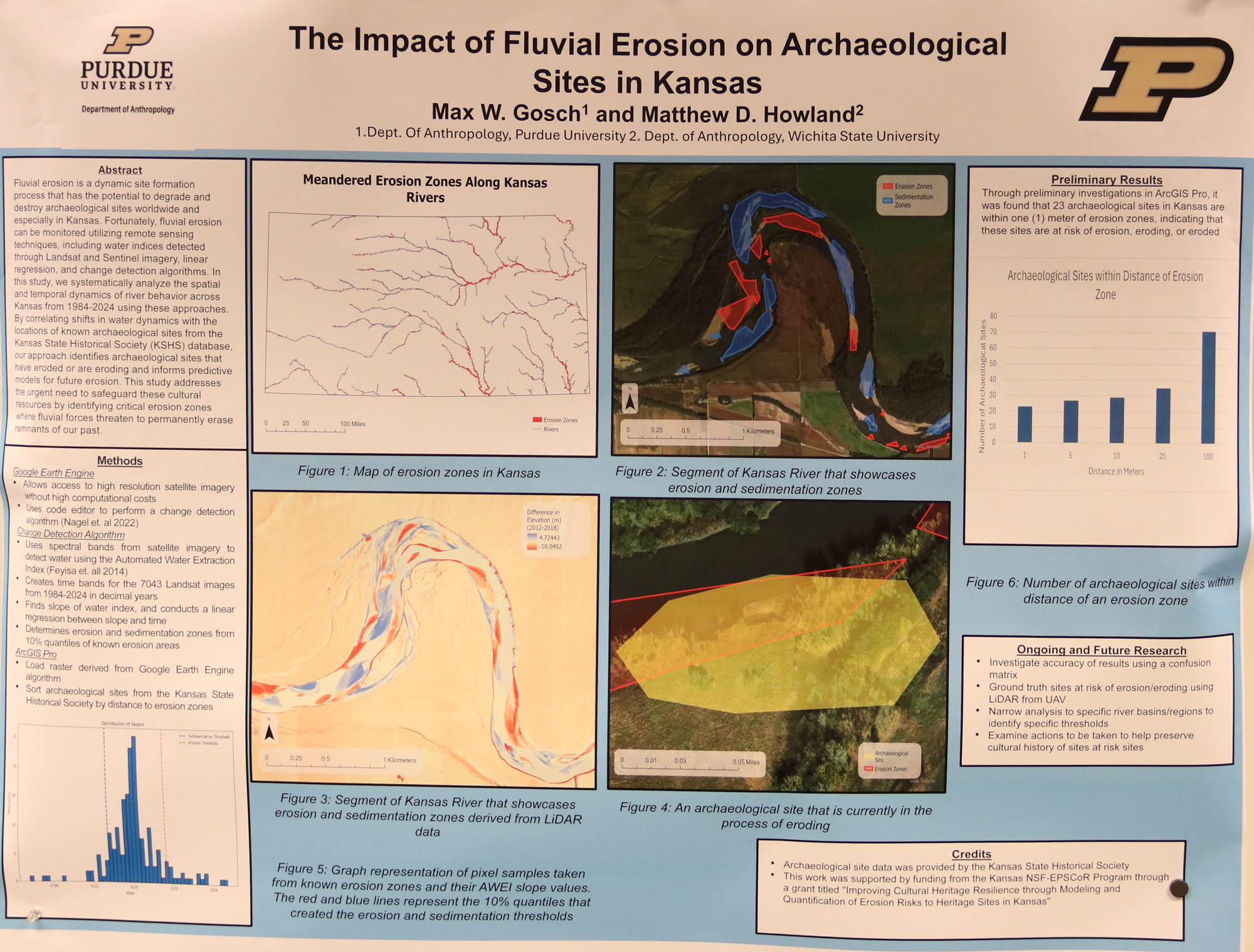
The Impact of Fluvial Erosion on Archaeological Sites
Max Gosch
Graduate student
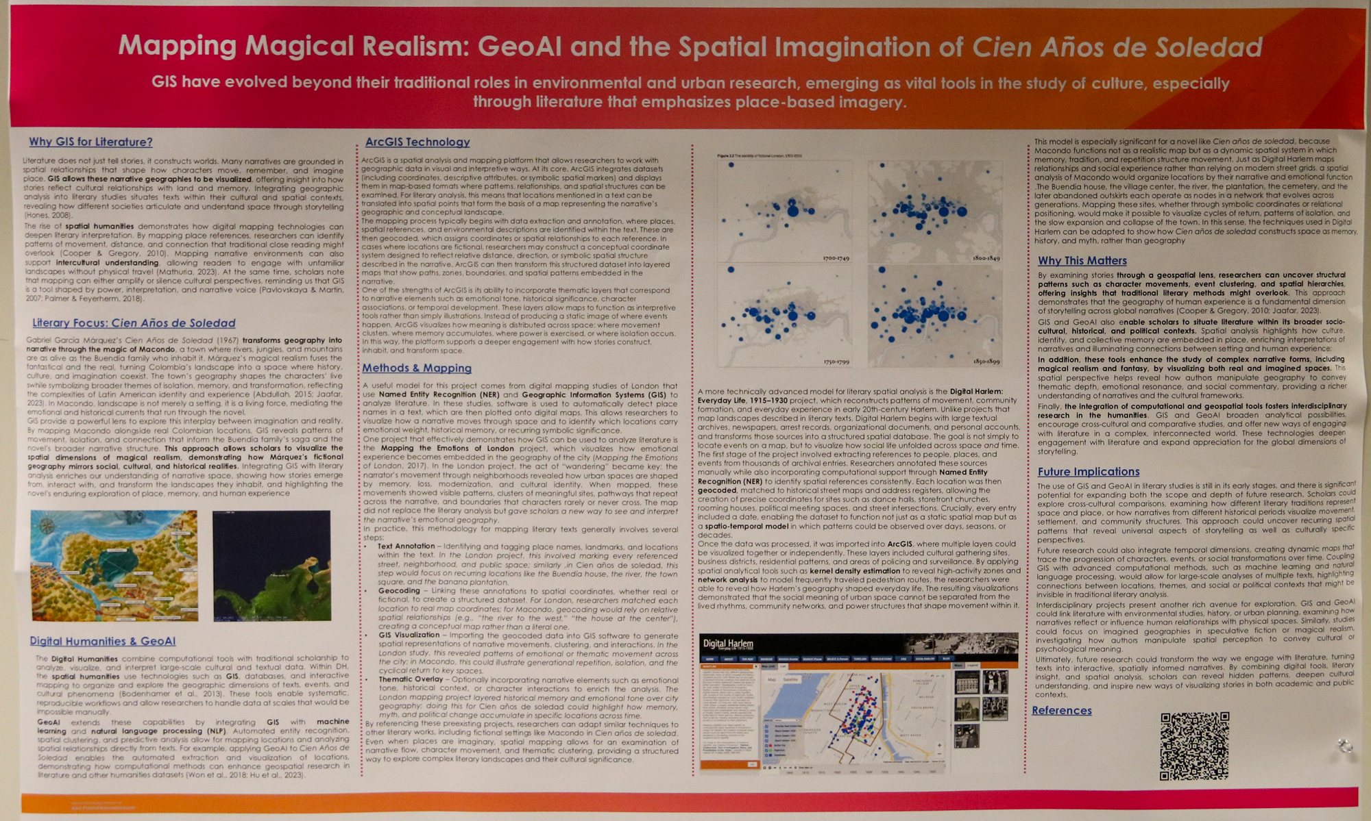
Mapping Magical Realism: GeoAI and the Spatial Imagination of Cien Años de Soledad
Sophia Pimentel
Undergraduate student
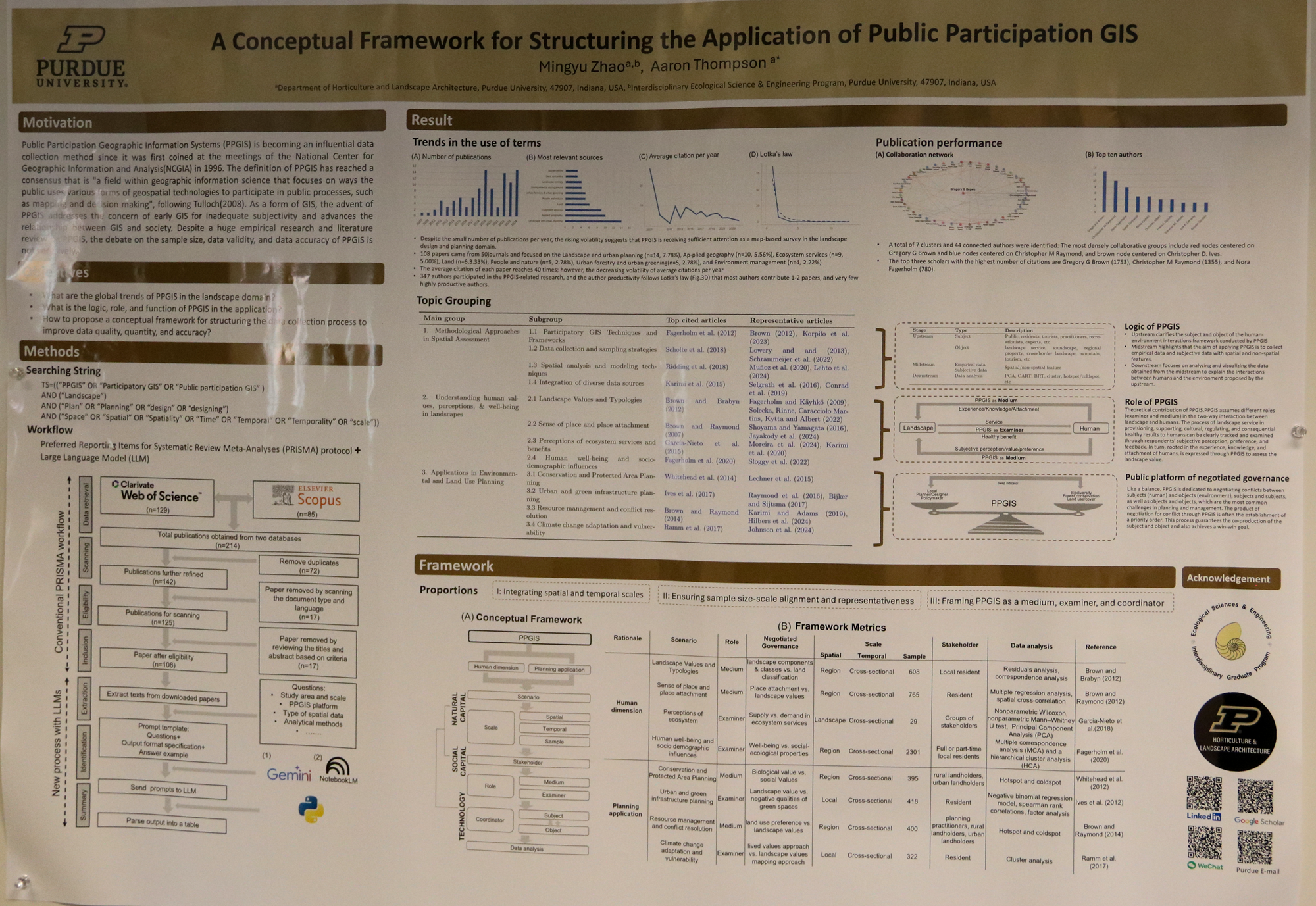
A Conceptual Framework for Structuring the Application of Public Participation GIS
Mingyu Zhao
Graduate student
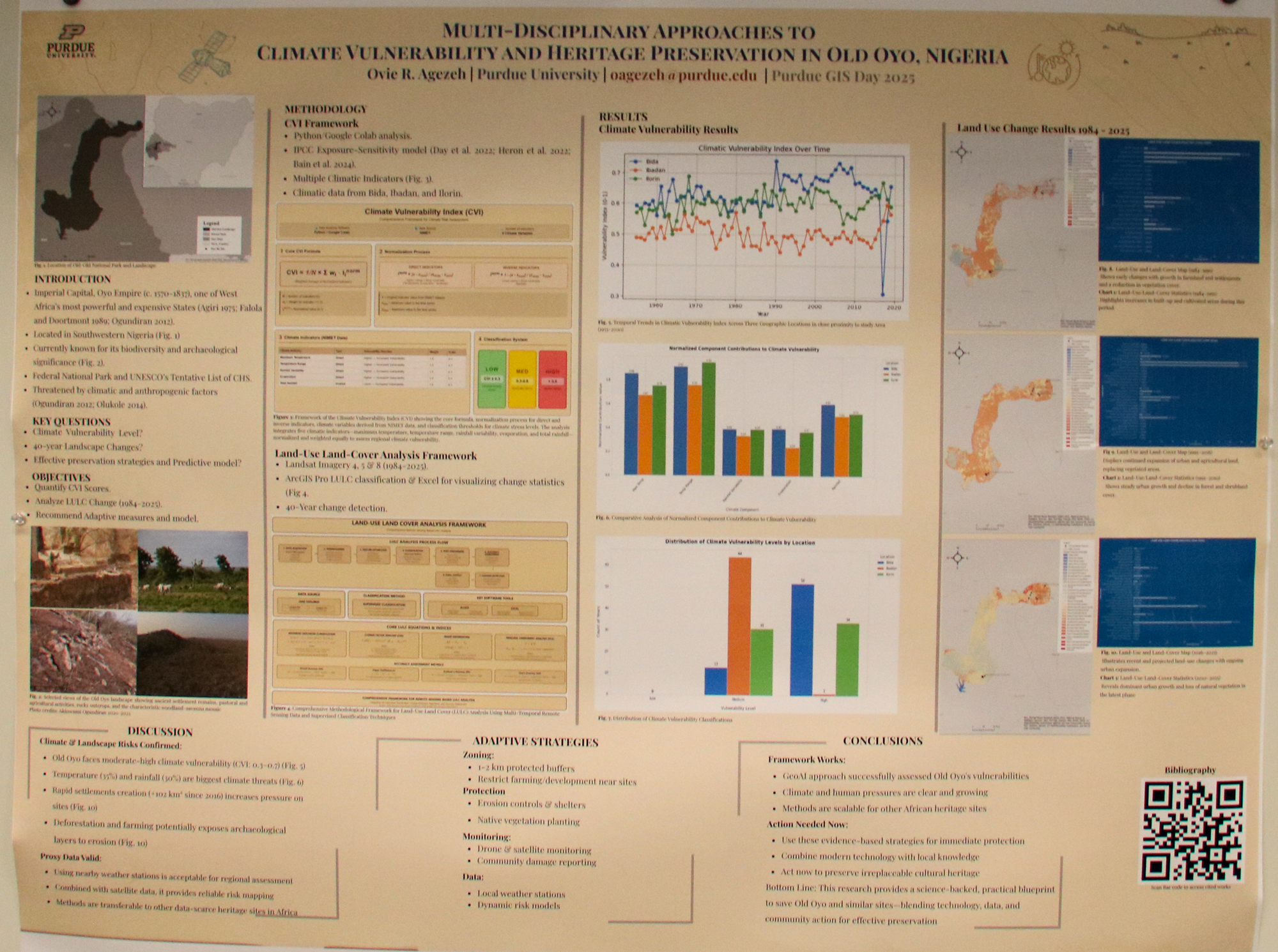
A Multi-Scalar GeoAI Approach: Integrating Climate Vulnerability and Remote Sensing for Sustainable Heritage Management at Old Oyo, Nigeria
Ovie Agezeh
Graduate student
Anthropology
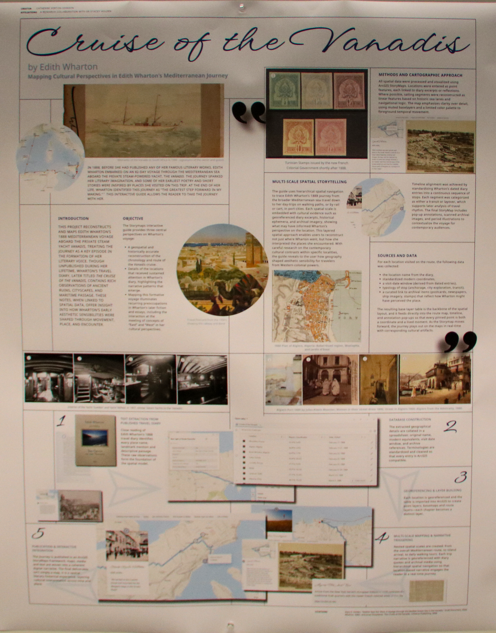
Cruise of the Vanadis: An Interactive Companion Guide
Catherine Kerton-Johnson
Graduate student
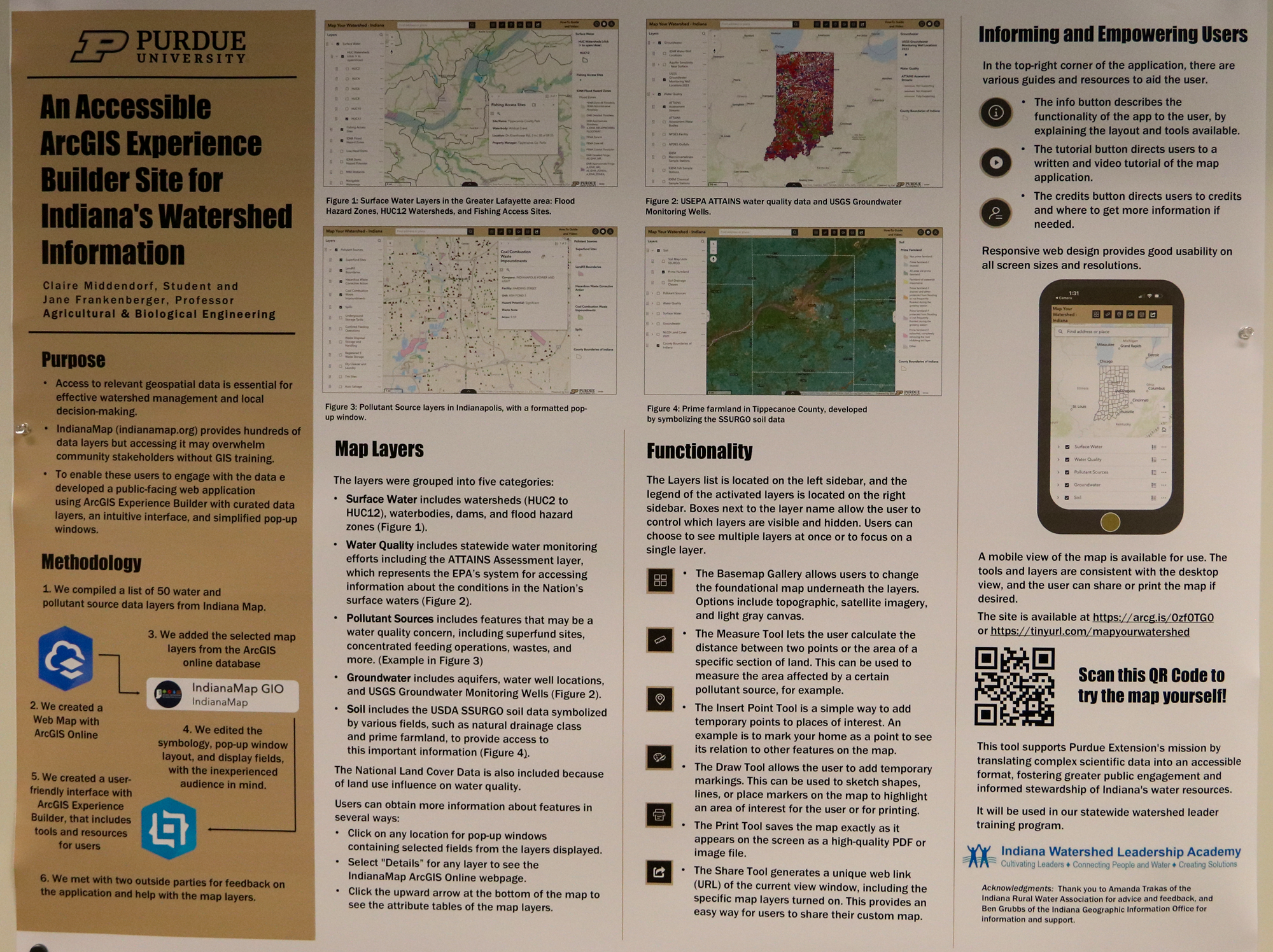
An Accessible ArcGIS Experience Builder Site for Indiana’s Watershed Information
Claire Middendorf
Undergraduate student
Environmental and Ecological Engineering
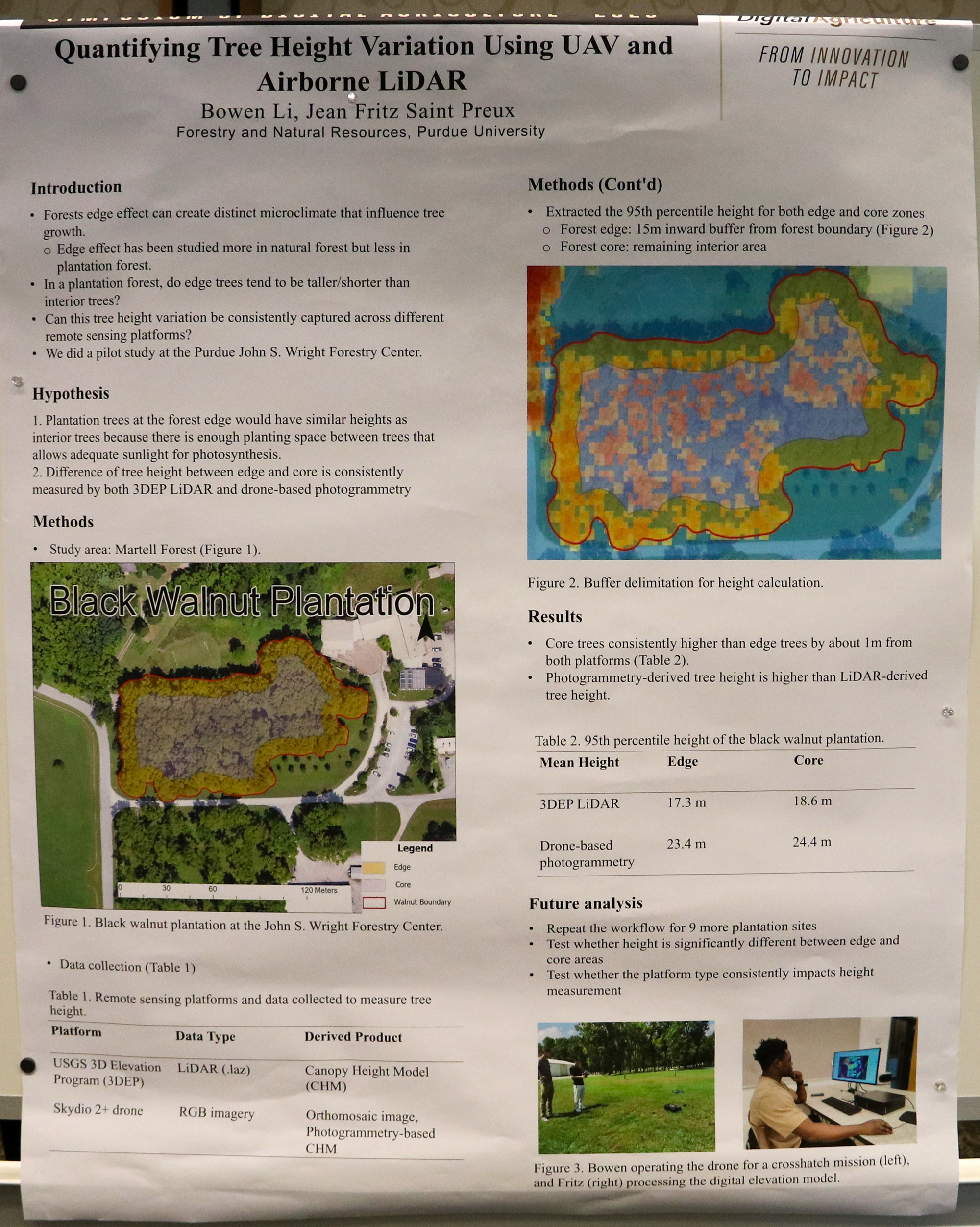
Quantifying Tree Height Variation Using UAV and Airborne Lidar
Jean Fritz Saint Preux
Graduate student
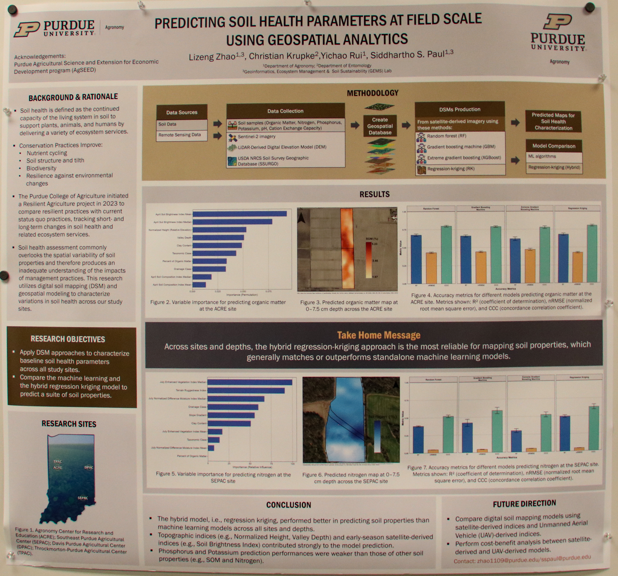
Predicting Soil Health Parameters at Field Scale Using Geospatial Analytics
Lizeng Zhao
Graduate student
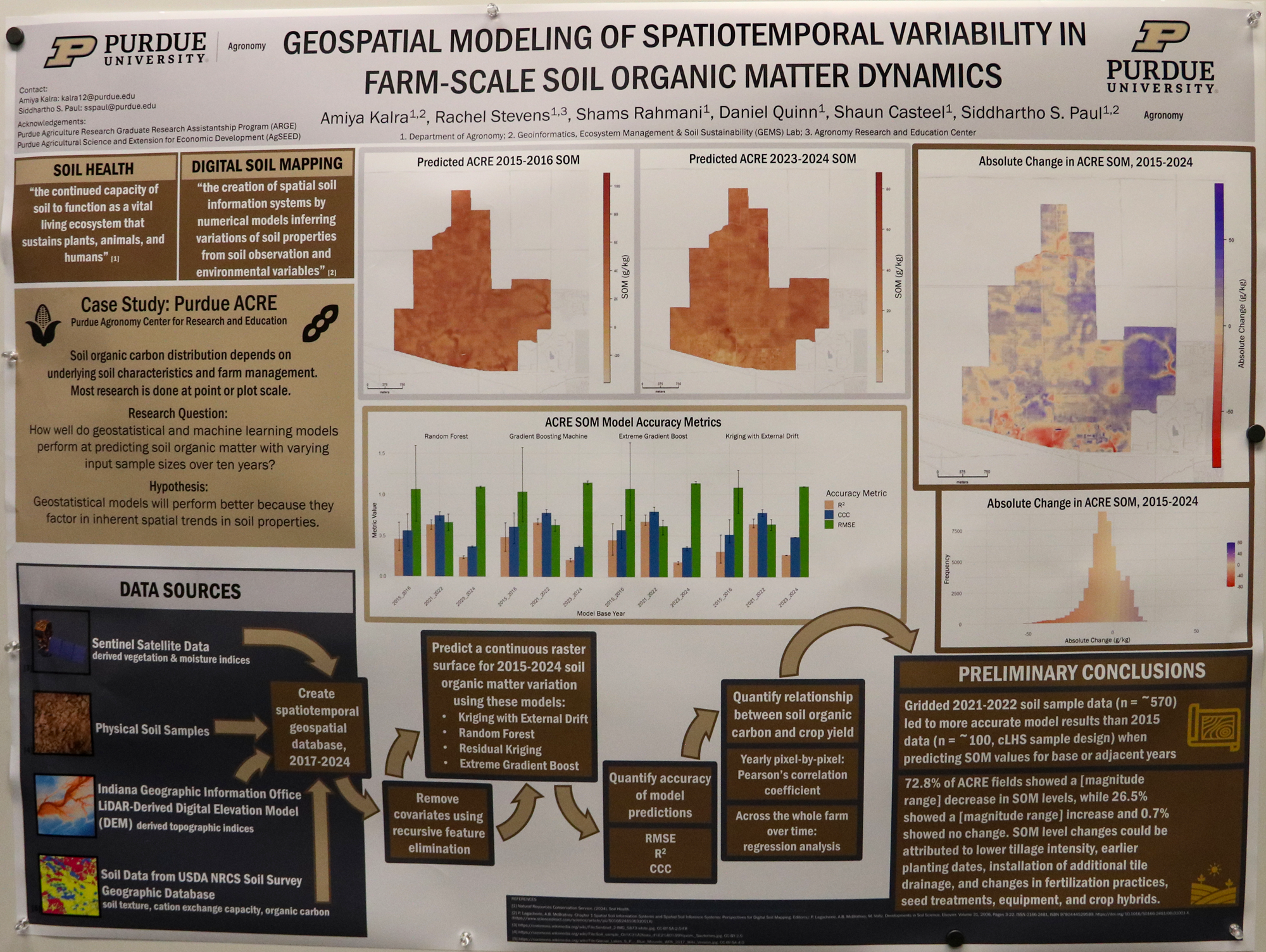
Geospatial Modeling of Spatiotemporal Variability in Farm-Scale Soil Organic Matter Dynamics
Amiyra Kalra
Graduate student
College of Agriculture
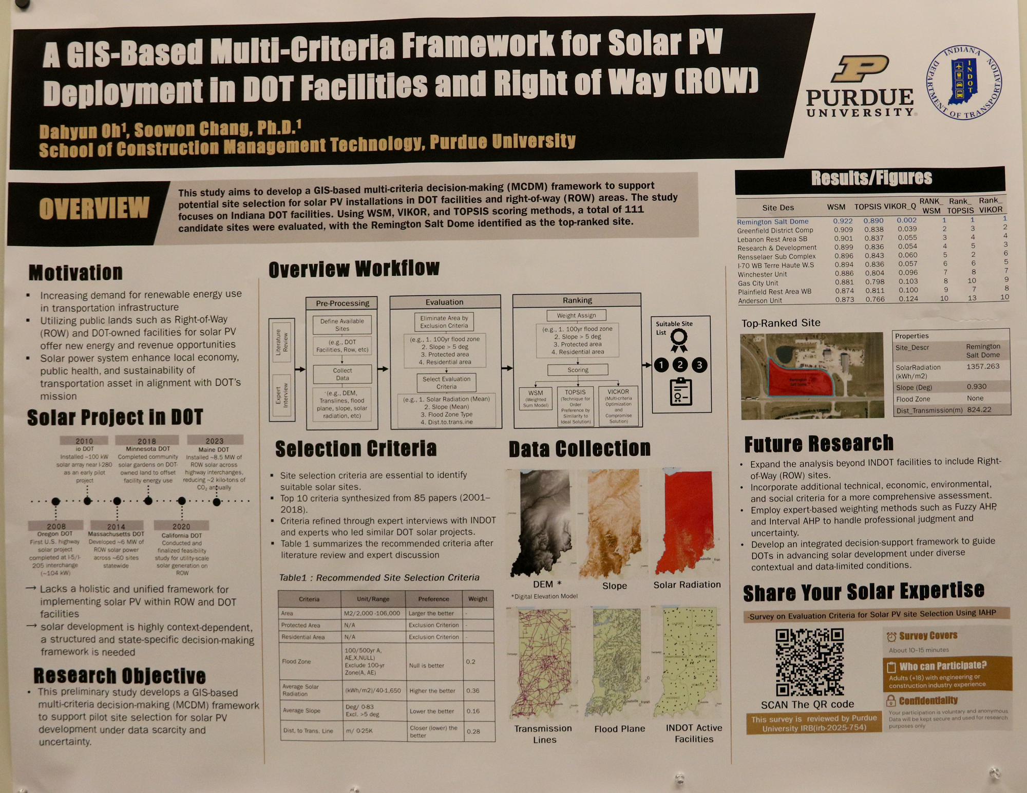
GIS-Based Multi-Criteria Decision Framework for Optimal Solar PV Site Selection in Transportation Infrastructure and Right-of-Way
Dahyun Oh
Graduate student
Construction Management Technology
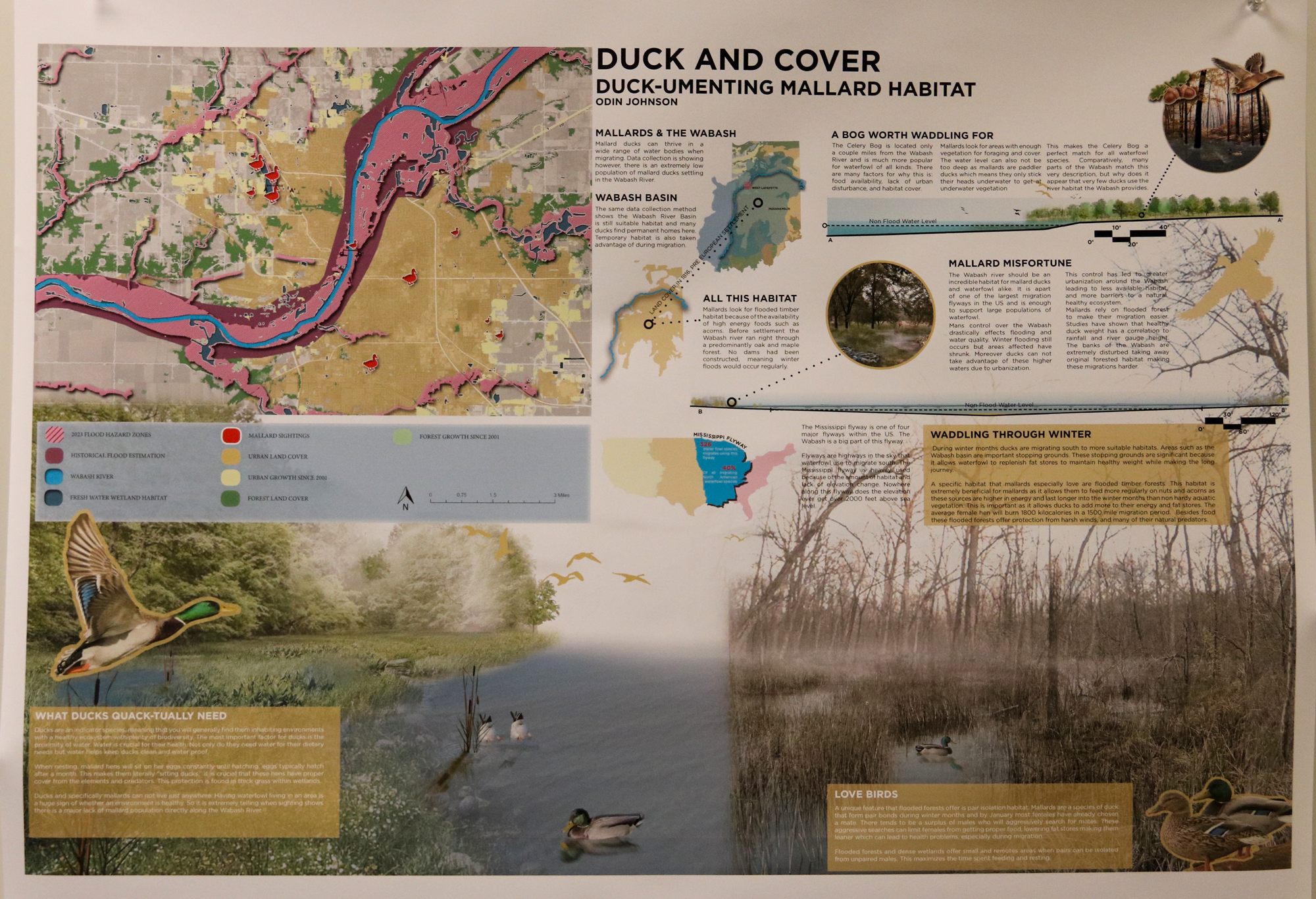
Duck and Cover – Duck-umenting Mallard Habitat
Odin Johnson
Undergraduate student
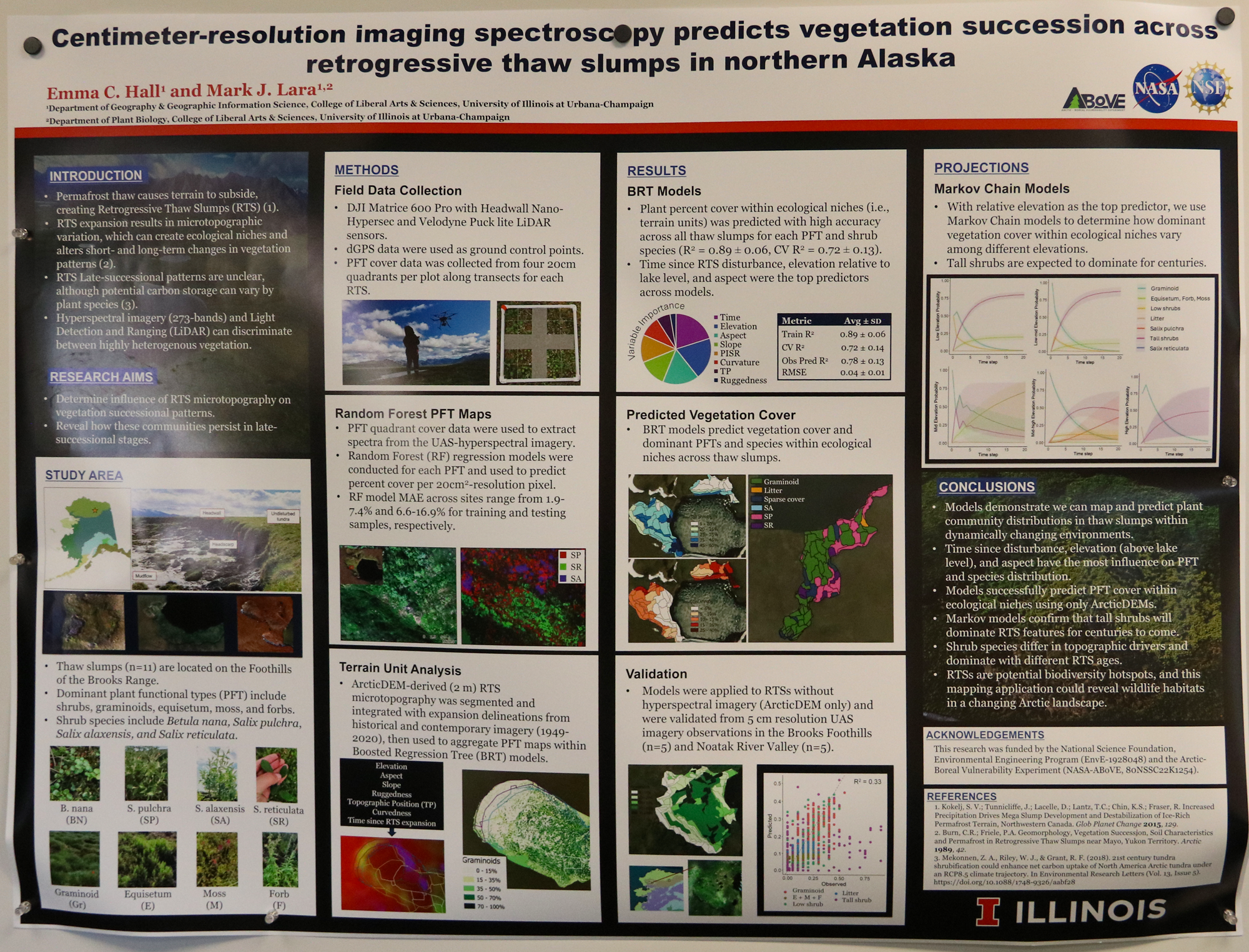
Centimeter-resolution imaging spectroscopy predicts vegetation succession across Retrogressive Thaw Slumps in northern Alaska
Emma Hall
Graduate student
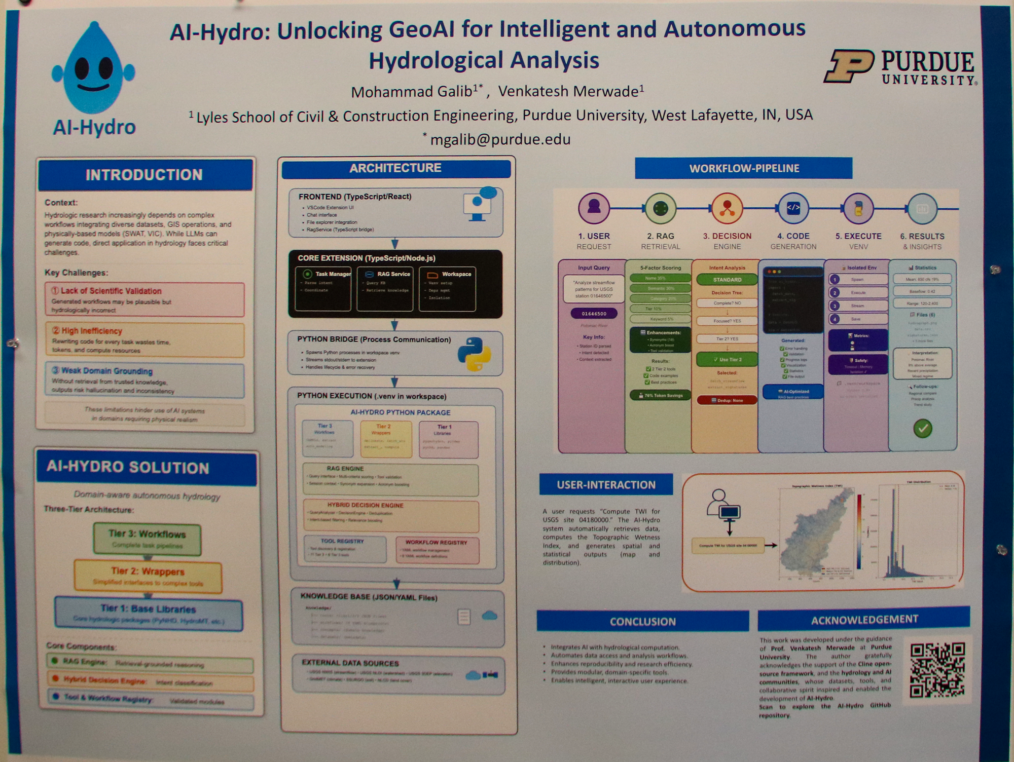
AI-Hydro: Unlocking GeoAI for Intelligent and Reproducible Hydrologic Data Science
Mohammad Galib
Graduate student
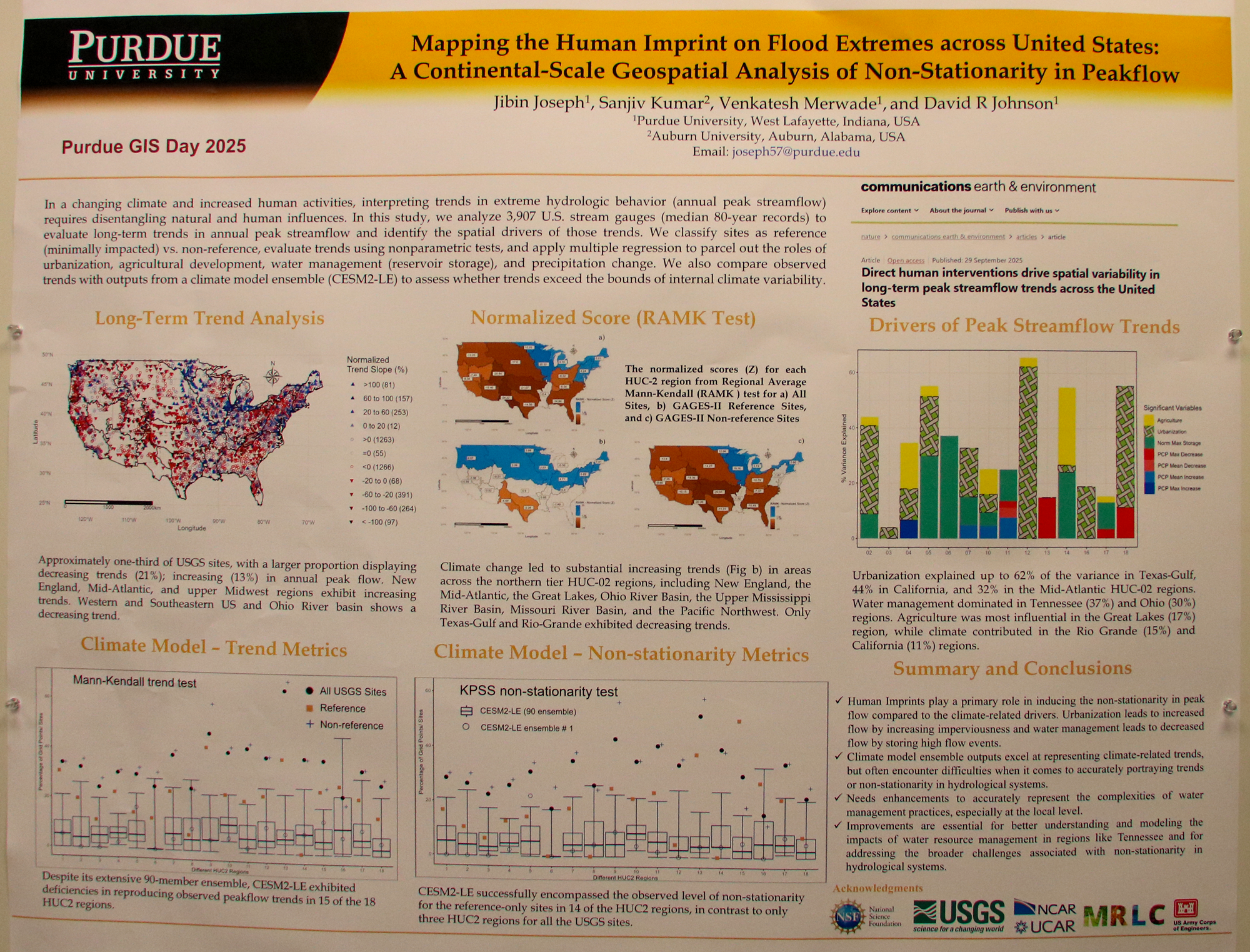
Mapping the Human Imprint on Flood Extremes across United States: A Continental-Scale Geospatial Analysis of Non-Stationarity in Peakflow
Joseph Jibin
Graduate student
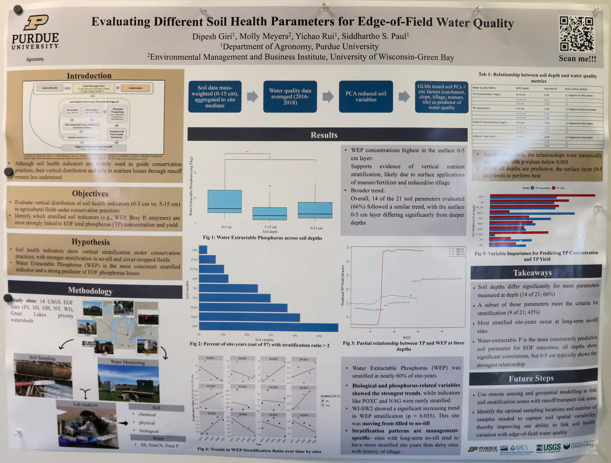
Evaluating Different Soil Health Parameters for Edge-of-Field Water Quality
Dipesh Giri
Graduate student
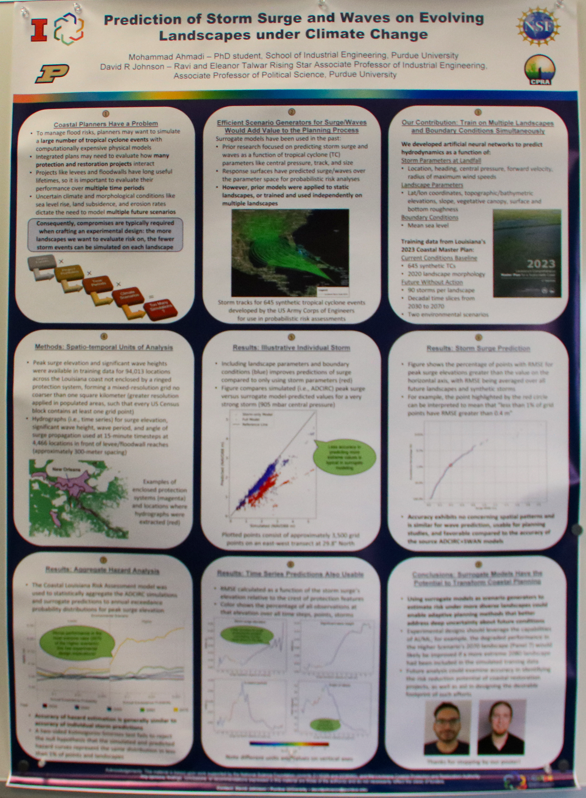
Prediction of Storm Surge and Waves on Evolving Landscapes under Climate Change
Mohammad Ahmadi
Graduate student
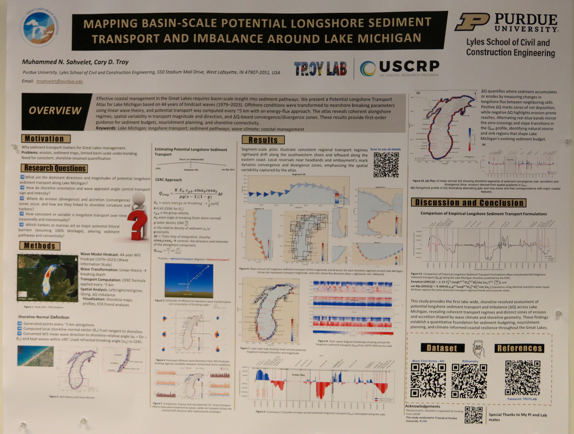
Mapping Basin-Scale Potential Alongshore Sediment Transport and Imbalance (ΔQ) Around Lake Michigan, 1979–2023
Muhammad N. Sahvelet
Graduate student
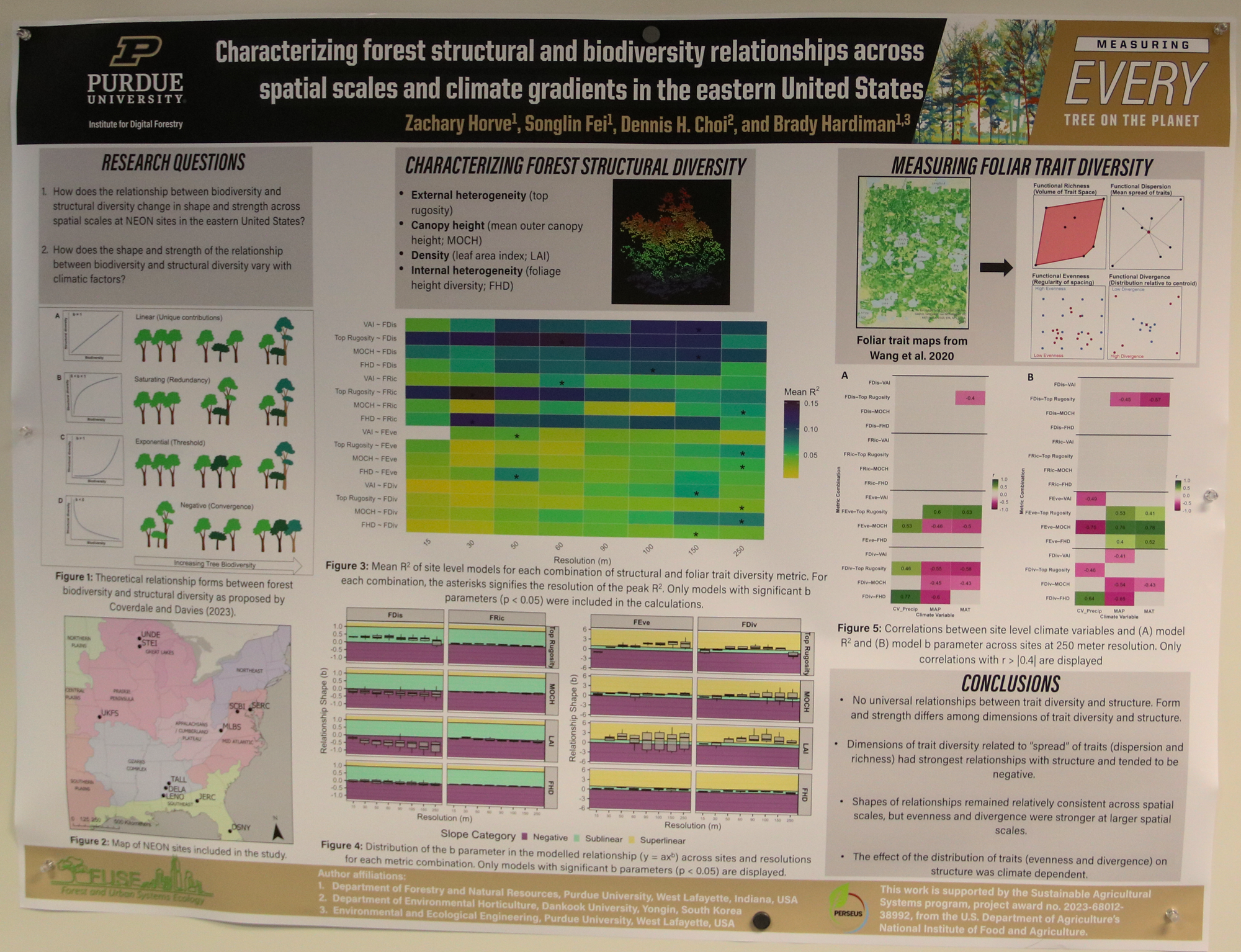
Characterizing forest structural and foliar trait diversity relationships across spatial scales and climate gradients in the eastern United States
Zack Horve
Graduate student
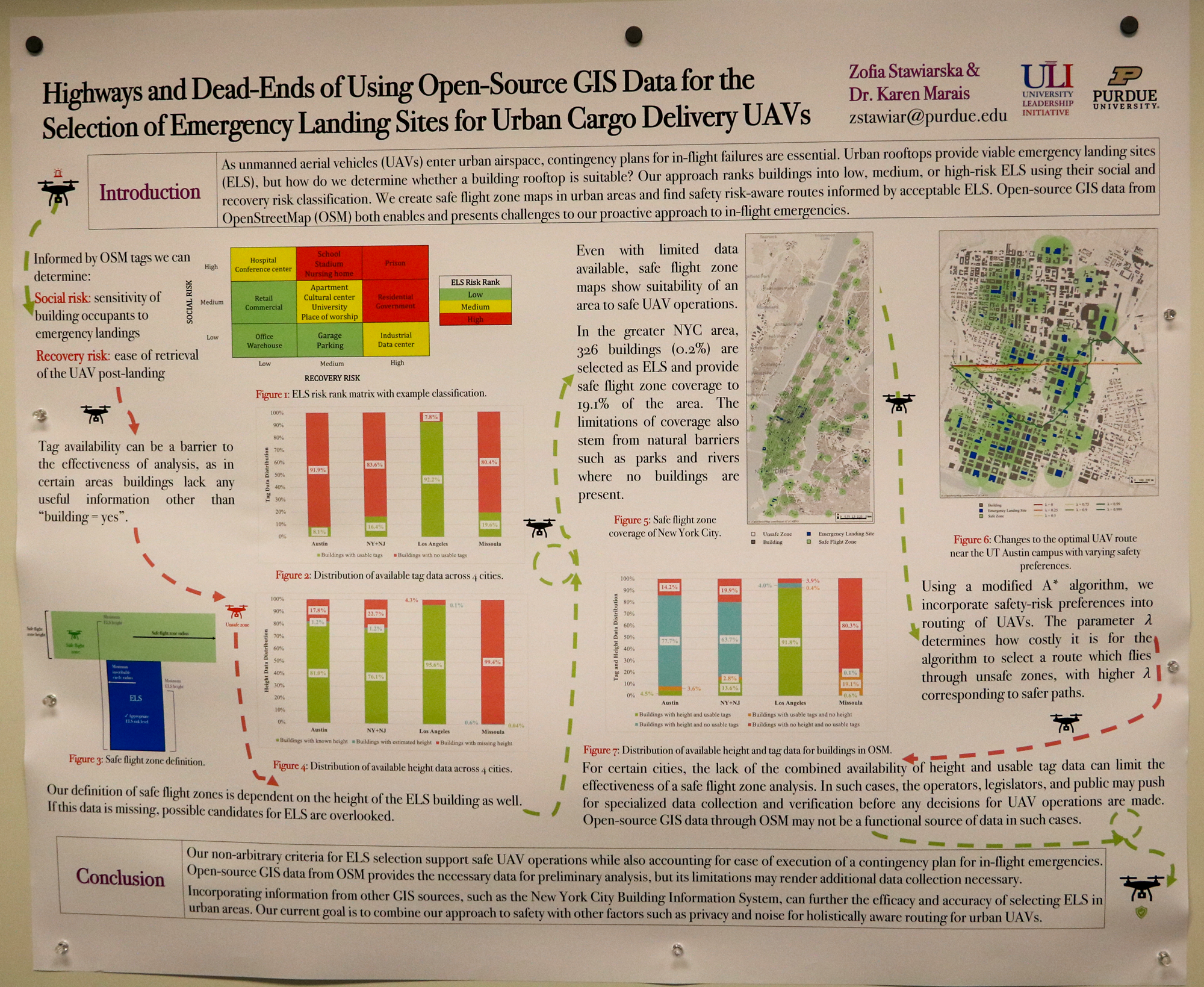
Highways and Dead-Ends of Using Open-Source GIS Data for the Selection of Emergency Landing Sites for Urban Cargo Delivery UAVs
Zofia Stawlarska
Graduate student
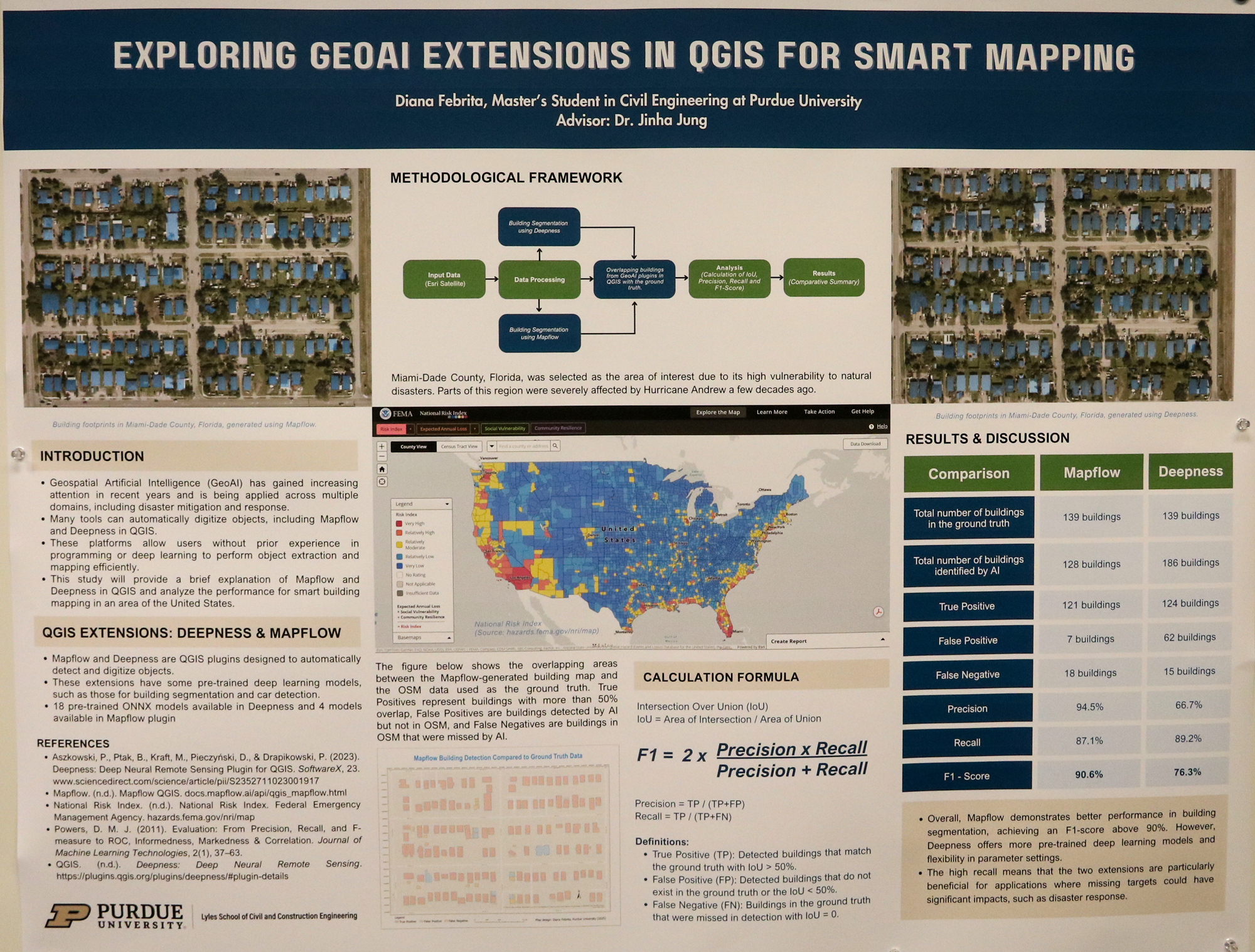
Exploring GeoAI Extensions in QGIS: A Comparative Analysis for Smart Mapping
Diana Febrita
Graduate student
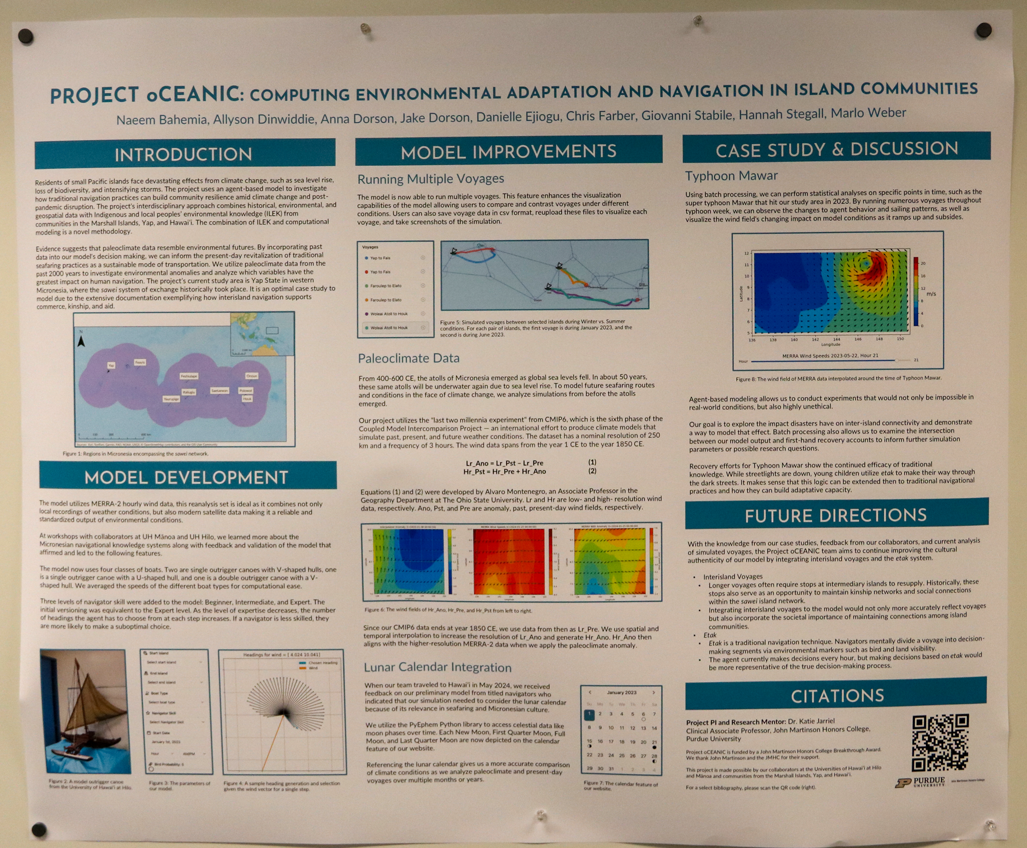
Project oCEANIC – Computing Environmental Adaptation and Navigation in Island Communities
Marlo Weber
Undergraduate student
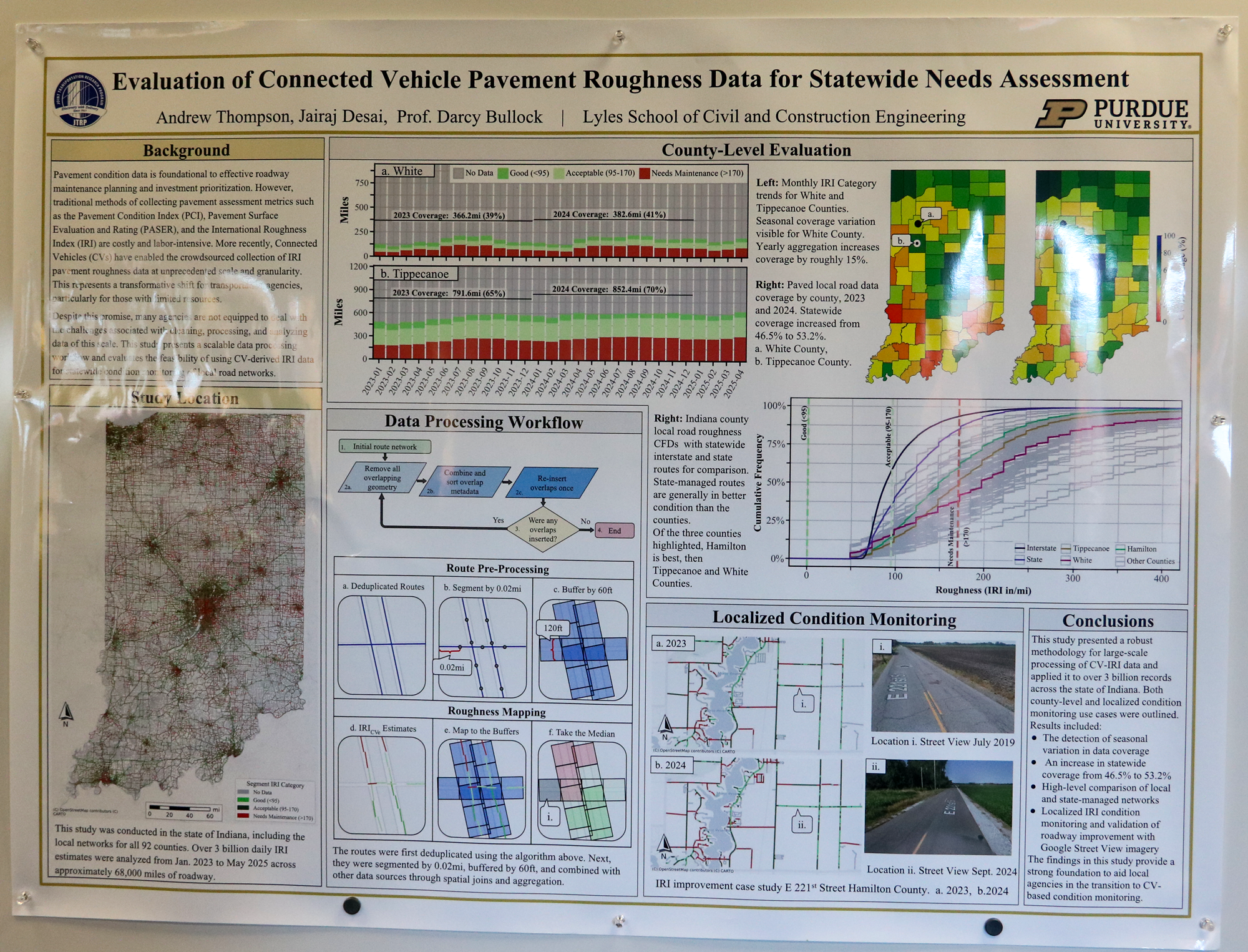
Evaluation of Connected Vehicle Pavement Roughness Data for Statewide Needs Assessment
Andrew Thompson
Undergraduate student
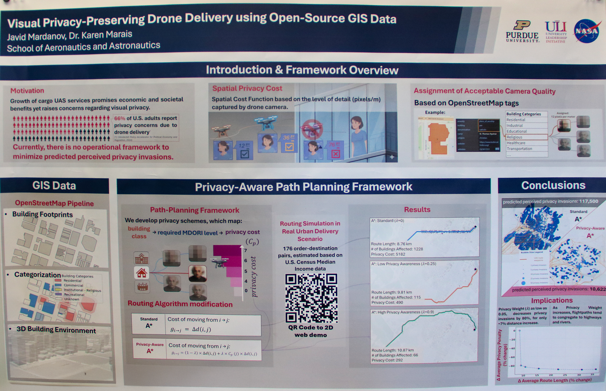
Visual Privacy-Preserving Drone Delivery using Open-Source GIS Data
Javid Mardanov
Graduate student
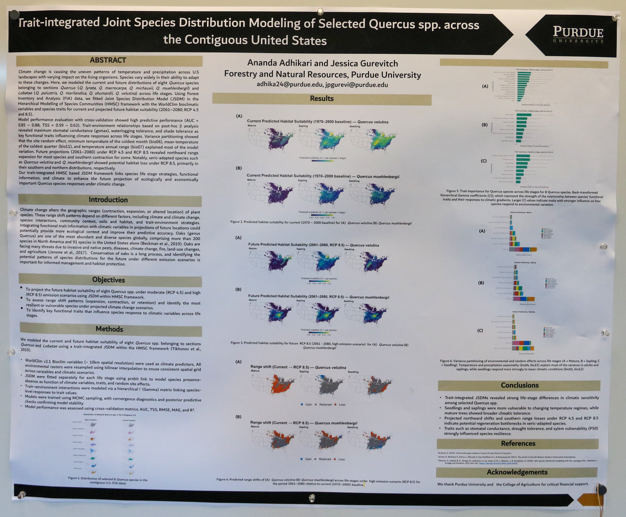
Trait-integrated Joint Species Distribution Modeling of Selected Quercus spp. across the Contiguous United States
Ananda Adhikari
Graduate student
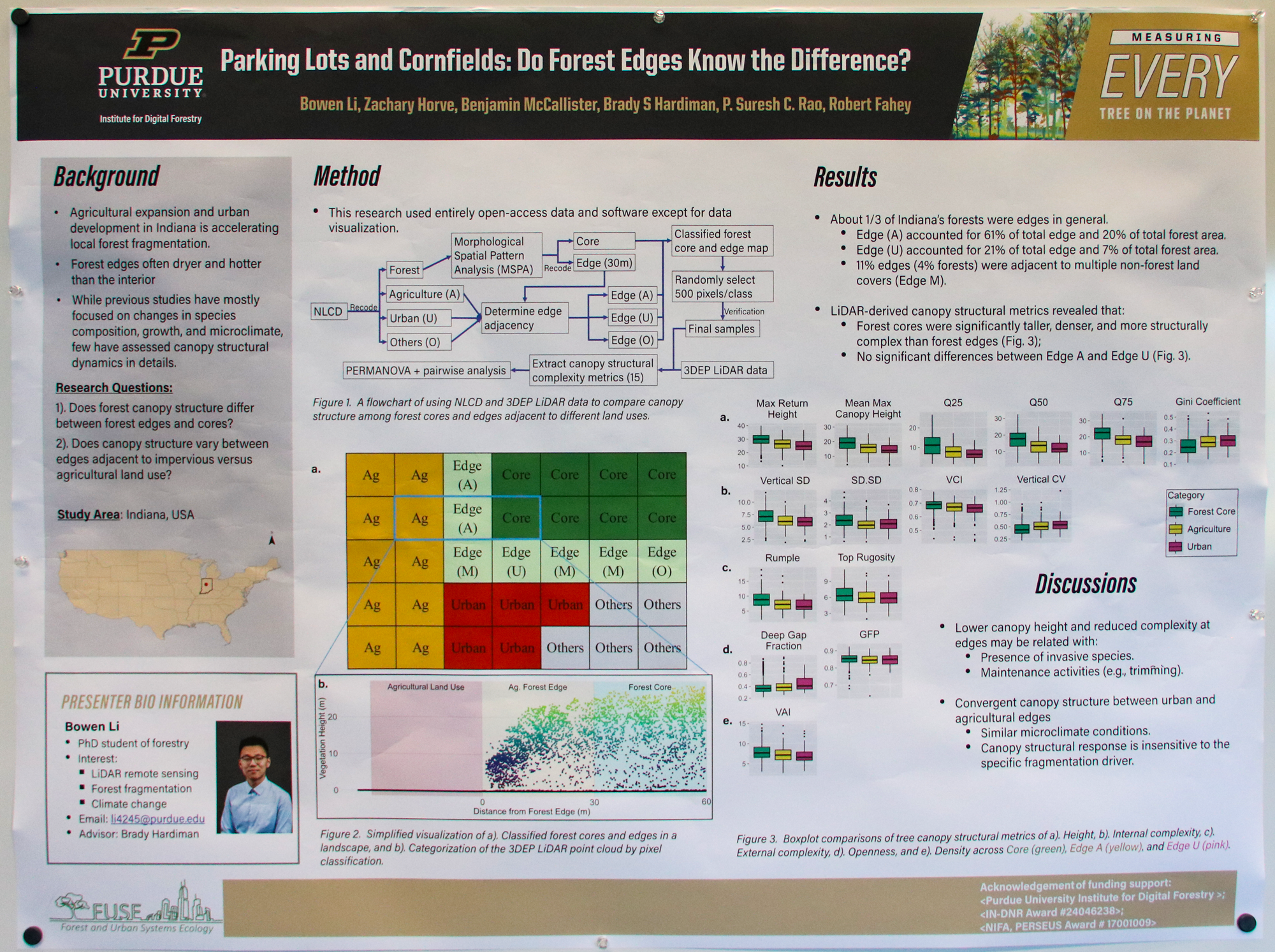
Parking Lots and Cornfields: Do Forest Edges Know the Difference?
Bowen Li
Graduate student

Fire Evaluation Reconnaissance and Direction Analysis (FERDA)
Abhishek Kaushikkar
Undergraduate student
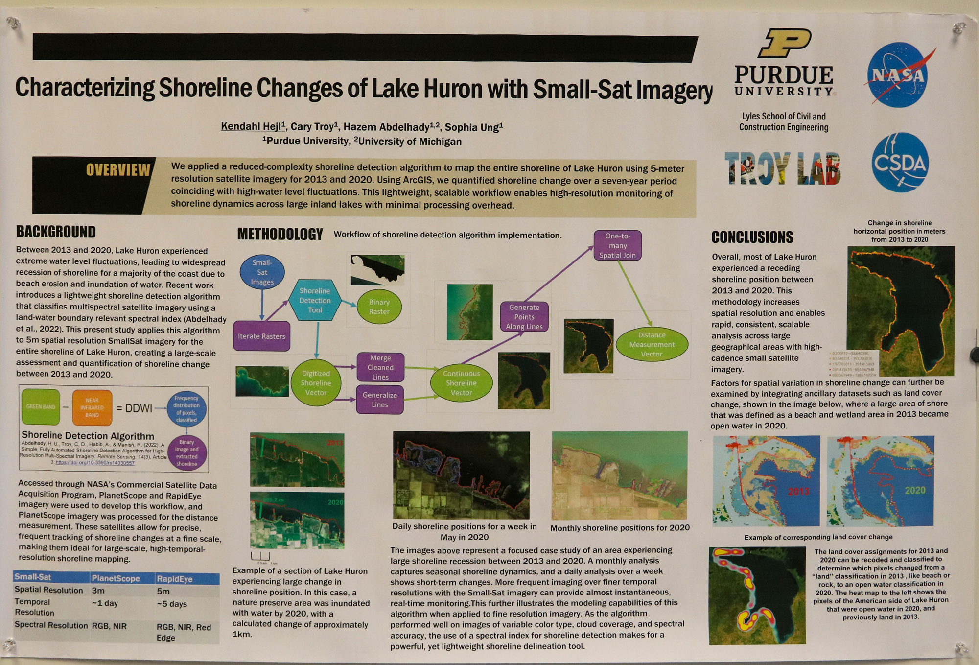
Characterizing Shoreline Changes of Lake Huron with Small-Sat Imagery
Kendahl Heji
Graduate student
Using GIS Across the Solar System to Unlock the Geologic History of Planets
Ali Bramson
Assistant Professor of Planetary Sciences
Purdue University
Data to Science: Open source ecosystem for GeoAI
Jinha Jung
Associate Professor of Civil Engineering, Geomatics
Purdue University
QGIS on HPC Clusters
Xiao Liu
Senior Research Software Engineer at the Rosen Center for Advanced Computing
Purdue University
Geospatial on AWS
David Conklin, Solutions Architect
Brian DeKemper, Enterprise Account Executive
Luke Coady, Solutions Architect
Amazon Web Services (AWS)
Hamilton County’s GeoAI Journey – 2024 Basemap Update Project Acquisition to Application
Joan Keene
GIS Director
Hamilton County, Indiana Government
GIS at the State of Indiana: The Role of the Indiana Geographic Information Office
Daniel Council, Geographic Information Outreach Coordinator
Shaun Scholer, GIS Technical Specialist (Programs and Outreach)
Indiana Geographic Information Office
Poster Award Winners
Undergraduate award winners:
- Sophia Pimentel, “Mapping Magical Realism: GeoAI and the Spatial Imagination of Cien Años de Soledad” (Digital Humanities winner)
- Andrew Thompson, “Evaluation of Connected Vehicle Pavement Roughness Data for Statewide Needs Assessment”
Graduate award winners:
- Max Gosch, “The Impact of Fluvial Erosion on Archaeological Sites in Kansas” (Digital Humanities winner)
- Kendahl Hejl, “Characterizing Shoreline Changes of Lake Huron with Small-Sat Imagery”
Recap
Learn more about how the 2025 conference went.