Highlights Purdue GIS Day 2025: Unlocking GeoAI and Tools
Purdue GIS Day 2025, with the theme of “Unlocking GeoAI Data and Tools,” was a success and brought together over 200 students, academics, and industry professionals in a day filled with insightful talks, poster presentations, and networking opportunities. The event, hosted by Gang Shao, showcased the latest advancements in geospatial analysis and its applications across many disciplines.
The success of this year’s event was made possible through the generous support of Purdue Libraries and School of Information Studies, Amazon Web Services (AWS), Cultivate Geospatial, and Ecopia AI. Their partnership continues to foster collaboration between academia and industry, advancing the development and application of geospatial technologies at Purdue and beyond.
The conference featured keynote speaker Gregory Brunner, an experienced scientist, award-winning professor, and principal data scientist at Esri, a global market leader in GIS software. His talk, titled “Integrating AI Across GIS,” explored innovative ways to apply artificial intelligence tools within geographic information systems to enhance analysis, visualization, and decision-making. He discussed using AI to assess the extent of building damage following hurricanes and to identify specific landmarks, as well as understand how they are utilized. Brunner enjoyed getting the opportunity to connect with students throughout the day and share his insights and professional experience with GIS.
Reflecting on his experience at this year’s conference, Brunner said, “I’ve really enjoyed it. I had a great experience last year; this year was a great experience, too. I love getting to talk to the students and hear about their posters.” He added that many of the projects this year involved AI or machine learning, noting, “It just seems like AI and machine learning have become so pervasive that all the students seem to be using it.”
The schedule also featured 29 research posters presented by undergrad and graduate students that connected their respective disciplines to the field of GIS. In addition, industry partners shared valuable insights through four research and industry presentations and a career panel discussion, highlighting the practical applications of geospatial technologies and strengthening connections between academia and industry. New this year was a Purdue faculty panel, where professors shared their research areas and inspired students through their insights. From learning about how to build an open geospatial data ecosystem to finding and accessing statewide GIS data, the speakers highlighted the relevance of these tools in real-world scenarios.
A special thanks to the following individuals for their involvement, participation, and professional insights shared with attendees during the panel discussion and/or their research and industry presentation:
- Ali Bramson, assistant professor of planetary sciences, Purdue University
- Gregory Brunner, principal data scientist, Esri
- Marianne Cardwell, geographic information officer, State of Indiana
- Luke Coady, solutions architect, Amazon Web Services (AWS)
- David Conklin, solutions architect, Amazon Web Services (AWS)
- Daniel Council, geographic information outreach coordinator, Indiana Geographic Information Office (IGIO)
- Brian DeKemper, enterprise account executive, Amazon Web Services (AWS)
- Songlin Fei, professor and iDiF director for Forestry & Natural Resources, Purdue University
- Jinha Jung, associate professor of civil engineering, Geomatics, Purdue University
- Joan Keene, GIS director, Hamilton County, Indiana Government
- Nicole Kong, professor of gis and associate dean for research for Libraries and School of Information Studies, Purdue University
- Ian Lindsay, associate professor of anthropology, Purdue University
- Xiao Liu, senior research software engineer, Rosen Center for Advanced Computing, Purdue University
- Thomas Peck, senior associate, Ecopia AI
- Shaun Scholer, GIS program director, State of Indiana
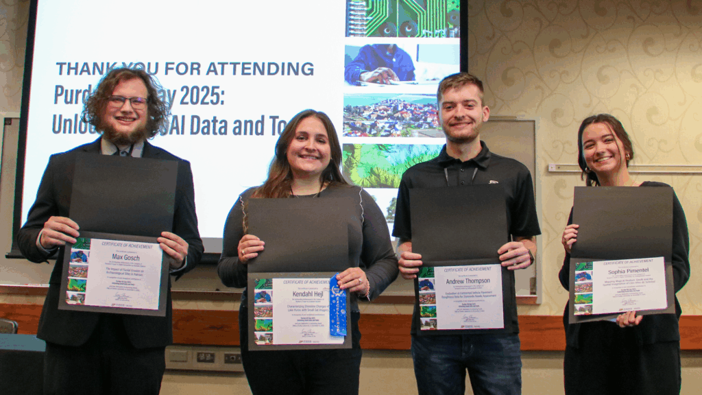
The day concluded with the recognition of the best graduate and undergraduate student poster presenters, including Digital Humanities award winners in both categories—a new award introduced this year. Each winner received a certificate and a $100 cash prize in acknowledgment of their unique contributions to the field of GIS. In addition, graduate student winners were awarded one-year ArcGIS for Personal Use licenses, each valued at $100, to further support their continued learning and research in geospatial science.
Undergraduate award winners:
- Sophia Pimentel, “Mapping Magical Realism: GeoAI and the Spatial Imagination of Cien Años de Soledad” (Digital Humanities winner)
- Andrew Thompson, “Evaluation of Connected Vehicle Pavement Roughness Data for Statewide Needs Assessment”
Graduate award winners:
- Max Gosch, “The Impact of Fluvial Erosion on Archaeological Sites in Kansas” (Digital Humanities winner)
- Kendahl Hejl, “Characterizing Shoreline Changes of Lake Huron with Small-Sat Imagery”
Congratulations to all of this year’s winners for their exceptional achievements, and to every participant of Purdue GIS Day 2025 for their valuable contributions to the field of geographic information systems. Your curiosity, creativity, and dedication made the event truly inspiring. We look forward to continuing this tradition of learning and collaboration; be sure to mark your calendars for Purdue GIS Day 2026, which will take place on November 12, 2026.